| CPC G06V 20/35 (2022.01) [G06V 20/17 (2022.01); G06V 20/20 (2022.01); B64C 39/024 (2013.01); B64U 80/84 (2023.01); B64U 80/86 (2023.01); B64U 2101/00 (2023.01); B64U 2101/30 (2023.01); G05D 1/0246 (2013.01)] | 20 Claims |
|
1. A post-disaster conditions monitoring system, comprising:
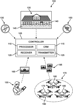
a conditions monitoring center having a controller including a device processor configured to perform the following steps:
sending a request to volunteer services of a personal aircraft drone to a user of the system;
receiving an option to volunteer the services of the personal aircraft drone from the user of the system as one of a plurality of volunteered aircraft drones configured to take photographic images of a geographic region;
receiving an operator selection from the user of the system of one of surrendering control of the personal aircraft drone to the system and maintaining control of the personal aircraft drone;
receiving a selection from the user of the system of a selected portion of the geographic region that is unphotographed;
directing the personal aircraft drone to take at least one photographic image of the selected portion of the geographic region based on the operator selection to add to the photographic images of the geographic region;
receiving the photographic images of the geographic region from the plurality of volunteered aircraft drones;
wherein at least one of the plurality of volunteered aircraft drones is configured to receive relayed photographic images from other drones in the geographic region and relay the relayed photographic images to the conditions monitoring center;
determining conditions in the geographic region based on the photographic images of the geographic region received from the plurality of volunteered aircraft drones;
detecting an obscured portion of the geographic region having an obscured aerial view;
directing at least one of a land vehicle drone and a watercraft drone to take additional photographic images of the obscured portion of the geographic region;
wherein the determining the conditions in the geography region is further based on the additional photographic images of the obscured portion of the geographic region;
sending information regarding the determined conditions to the user of the system;
preparing a map indicating the determined conditions within the geographic region; and
providing the map to the user of the system.
|
|
10. A post-disaster conditions monitoring system, comprising:
a conditions monitoring center having a controller including a device processor configured to perform the following steps:
sending a request to volunteer services of a personal aircraft drone to a user of the system;
receiving an option to volunteer the services of the personal aircraft drone from the user of the system as one of a plurality of volunteered aircraft drones configured to take photographic images of a geographic region;
receiving an operator selection from the user of the system of one of surrendering control of the personal aircraft drone to the system and maintaining control of the personal aircraft drone;
receiving a selection from the user of the system of a selected portion of the geographic region that is unphotographed;
directing the personal aircraft drone to take at least one photographic image of the selected portion of the geographic region based on the operator selection to add to the photographic images of the geographic region;
wherein the personal aircraft drone is selected to have a sufficient communications range and battery life to be able to travel from one edge to an opposite edge of the geographic region while in contact with the conditions monitoring center;
selecting whether the personal aircraft drone is operable via one of remote control and autonomous operation;
sending a request to volunteer battery charging services to the user of the system;
receiving an option to volunteer the battery charging services from the user of the system as one of a plurality of volunteered battery charging services configured to provide battery charging in a geographic region;
receiving the photographic images from the plurality of volunteered aircraft drones in the geographic region;
determining conditions in the geographic region based on the photographic images received from the plurality of volunteered aircraft drones;
detecting an obscured portion of the geographic region having an obscured aerial view;
directing at least one of a land vehicle drone and a watercraft drone to take additional photographic images of the obscured portion of the geographic region;
wherein the determining the conditions in the geography region is further based on the additional photographic images of the obscured portion of the geographic region;
sending information regarding the determined conditions to the user of the system;
preparing a map indicating the determined conditions within the geographic region;
providing the map to the user of the system;
sharing the volunteered battery charging services with drones requiring recharging; and
instructing a drone to use the volunteered battery charging services.
|
|
17. A post-disaster conditions monitoring system, comprising:
a conditions monitoring center having a controller including a device processor configured to perform the following steps:
sending a request to volunteer services of a personal aircraft drone to a user of the system;
receiving an option to volunteer the services of the personal aircraft drone from the user of the system as one of a plurality of volunteered aircraft drones configured to take photographic images of a geographic region;
receiving an operator selection from the user of the system of one of surrendering control of the personal aircraft drone to the system and maintaining control of the personal aircraft drone;
receiving a selection from the user of the system of a selected portion of the geographic region that is unphotographed;
directing the personal aircraft drone to take at least one photographic image of the selected portion of the geographic region based on the operator selection to add to the photographic images of the geographic region;
receiving the photographic images of the geographic region from the plurality of volunteered aircraft drones;
wherein at least one of the plurality of volunteered aircraft drones is configured to receive relayed photographic images from other drones in the geographic region and relay the relayed photographic images to the conditions monitoring center;
detecting an obscured portion of the geographic region having an obscured aerial view;
directing at least one of a land vehicle drone and a watercraft drone to take additional photographic images of the obscured portion of the geographic region;
determining conditions in the geographic region based on the photographic images of the geographic region received from the plurality of volunteered aircraft drones and the additional photographic images of the obscured portion of the geographic region;
sending information regarding the determined conditions to the user of the system;
preparing a map indicating the determined conditions within the geographic region; and
providing the map to the user of the system.
|