| CPC G06Q 50/28 (2013.01) [B64C 39/024 (2013.01); G06Q 10/06314 (2013.01); G06Q 10/0835 (2013.01); G06Q 10/08355 (2013.01); G08G 5/0043 (2013.01); B64U 2101/60 (2023.01); B64U 2201/102 (2023.01)] | 19 Claims |

|
1. A method of scheduling transports by a fleet of unmanned aerial vehicles (UAVs) said method comprising:
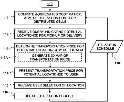
computing aggregated cost data for the fleet of UAVs based on current and/or future locations of the UAVs within a geographic region, the aggregated cost data associating energy consumption with distributed sub-regions within the geographic region, the energy consumption of a respective sub-region representing an estimated cost for directing at least one of the UAVs to the respective sub-region;
receiving a query indicative of one or more potential locations for pick-up or delivery of a payload;
determining, based on the aggregated cost data, a transportation price for at least one potential location among the one or more potential locations;
determining a count of available UAVs for the respective sub-region;
counting cost values that are smaller than a threshold cost among the cost values associated with the respective sub-region;
selecting a final delivery area among the one or more potential locations based on the cost values that are smaller than the threshold cost for the respective sub-region and the transportation price for the one or more potential locations; and
operating at least one of the UAVs from among a fleet of the UAVs to pick-up or deliver the payload to the final delivery area, wherein operating the at least one of the UAVs to pick-up or deliver the payload to the final delivery area includes:
determining a drag value of the at least one UAVs, wherein the drag value is indicative of an air resistance of the at least one UAVs,
determining a relative position of the at least one UAVs based on the drag value of the at least one UAVs, and
controlling the operation of the at least one UAVs based on the relative position of the at least one UAVs,
wherein the energy consumption for the respective sub-region is given by a cost value reduced as a function of the count of available UAVs for the respective sub-region, and
wherein the relative position of the at least one UAVs defines a respective position of a predefined spatial arrangement defined by the fleet of the UAVs.
|