| CPC G05D 1/042 (2013.01) [B64C 39/024 (2013.01); B64D 1/18 (2013.01); G05D 1/101 (2013.01); G06T 19/003 (2013.01); G06V 20/188 (2022.01); A01C 7/085 (2013.01); B64U 2101/00 (2023.01); G05D 2201/0201 (2013.01); G06T 2207/10032 (2013.01); G06T 2207/20084 (2013.01); G06T 2207/30188 (2013.01)] | 16 Claims |

|
1. A spray operation method comprising:
obtaining two-dimensional position information of a target area and a three-dimensional model of the target area; and
obtaining an operation route according to the two-dimensional position information and the three-dimensional model, the operation route including a plurality of waypoints, and at least one of the waypoints being associated with altitude information;
wherein obtaining the operation route includes:
determining a planned route according to the two-dimensional position information; and
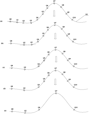
determining one or more key points on the planned route according to the three-dimensional model to obtain the operation route, each of the one or more key points being associated with altitude information, and the waypoints including the one or more key points; and
wherein determining the one or more key points on the planned route includes inputting the planned route and the three-dimensional model into a neural network model to obtain the one or more key points on the planned route.
|