| CPC G01V 1/48 (2013.01) [G01V 2210/514 (2013.01); G01V 2210/53 (2013.01)] | 9 Claims |
|
1. A method for optimally selecting a carbon storage site based on multi-frequency band seismic data, comprising:
using well logging instruments to generate original seismic data and well logging data at a known well site;
configuring an electronic equipment, comprising at least one processor, and a memory communicatively connected to the at least one processor, wherein the memory stores instructions that can be executed by the processor, and the instructions are used to be executed by the processor to realize the steps of:
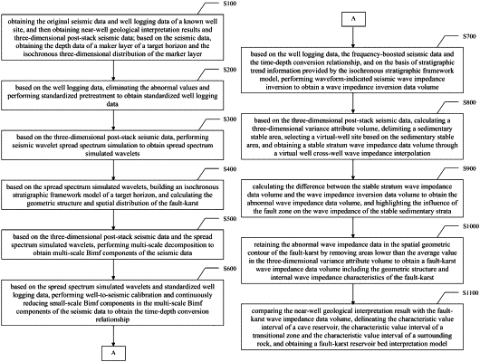
obtaining the original seismic data and well logging data of the known well site, and then obtaining near-well geological interpretation results and three-dimensional post-stack seismic data;
based on the three-dimensional post-stack seismic data, obtaining the depth data of a maker layer of a target horizon and the isochronous three-dimensional distribution of the marker layer;
based on the well logging data, eliminating the abnormal values and performing standardized pretreatment to obtain standardized well logging data;
based on the three-dimensional post-stack seismic data, performing seismic wavelet spread spectrum simulation to obtain spread spectrum simulated wavelets;
based on the spread spectrum simulated wavelets, building an isochronous stratigraphic framework model of a target horizon, and calculating the geometric structure and spatial distribution of the fault-karst;
based on the three-dimensional post-stack seismic data and the spread spectrum simulated wavelets, performing multi-scale decomposition to obtain multi-scale Bimf components of the seismic data;
based on the spread spectrum simulated wavelets and standardized well logging data, performing well-to-seismic calibration and ignoring small-scale Bimf components in the multi-scale Bimf components of the seismic data, thereby obtaining the time-depth conversion relationship;
based on the well logging data, the frequency-boosted seismic data, and the time-depth conversion relationship, and on the basis of stratigraphic trend information provided by the isochronous stratigraphic framework model, performing waveform-indicated seismic wave impedance inversion to obtain a wave impedance inversion data volume;
based on the three-dimensional post-stack seismic data, calculating a three-dimensional variance attribute volume, delimiting a sedimentary stable area, selecting a virtual-well site based on the sedimentary stable area, and obtaining a stable stratum wave impedance data volume through a virtual well cross-well wave impedance interpolation;
calculating the difference between the stable stratum wave impedance data volume and the wave impedance inversion data volume to obtain the abnormal wave impedance data volume, and highlighting the influence of the fault zone on the wave impedance of the stable sedimentary strata;
by removing areas lower than the average value in the three-dimensional variance attribute volume, retaining the abnormal wave impedance data in the spatial geometric contour of the fault-karst to obtain a fault-karst wave impedance data volume including the geometric structure and internal wave impedance characteristics of the fault-karst;
comparing the near-well geological interpretation result with the fault-karst wave impedance data volume, delineating a characteristic value interval of a cave reservoir, a characteristic value interval of a crack fractured zone, and a characteristic value interval of surrounding rock, and obtaining a fault-karst reservoir bed interpretation model; and
according to a fault-karst reservoir bed interpretation model, calculating migration and reservoir space after carbon dioxide injection, and finding a trap structure with a preset size threshold value, so that the migration and reservoir space where the injected carbon dioxide is stored in a high-density free phase under the conditions of being blocked by the tight carbonate rocks at the side of the fault zone and sealed by a top marl cover coat is selected as the position of the carbon storage box.
|