| CPC G01V 1/306 (2013.01) [G01V 1/282 (2013.01); G01V 1/302 (2013.01); G01V 99/005 (2013.01); G06N 20/00 (2019.01)] | 20 Claims |
|
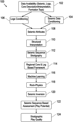
1. A computer-implemented stratigraphic play quality generation method, the method comprising:
i) receiving, by at least one computing device configured by executing instructions, data including seismic data and log data, respectively received from each of a plurality of respective data sources, wherein at least some of the seismic data include stratigraphic data;
ii) processing, by the at least one computing device using at least one of an imperial, statistical, and machine learning technique, at least some wireline data included in the log data to correct for a borehole condition associated with a geologic area, and to predict missing wireline data;
iii) determining, by the at least one computing device using the processed wireline data, seismic attributes including structural attributes and stratigraphic attributes;
iv) applying, by the at least one computing device, machine learning to generate a model from at least some of the received data to determine at least one seismic surface and at least one structural element;
v) transforming, by the at least one computing device using a seismic sequence model, at least some of the received data into a relative geological time model;
vi) determining, by the at the least one computing device using the relative geological time model, attributes of at least one seismic sequence including by decomposing a signal included in the received data into component frequencies and applying an additive color model;
vii) deriving from the seismic attributes, by the at least one computing device, a parameter respectively representing at least one of frequency, attenuation, amplitude character, and time;
viii) linking, by the at least one computing device, reservoir properties associated with the geologic area to elastic properties associated with the geologic area;
ix) building, by the at least one computing device, a seismic forward model having 2D synthetic sections that are populated with properties from log data, wherein the seismic forward model represents at least one stratigraphic feature of interest associated with the geologic area; and
x) processing, by the at least one computing device, at least some of the seismic forward model to increase resolution and to generate, by the at least one computing device as a function of the increased resolution, the attributes of the at least one seismic sequence, and the derived parameter, a 3D map that is usable for a prospective drilling plan.
|