US 11,851,085 B2
Navigation and mapping based on detected arrow orientation
Avigdor Eldar, Modiin (IL); Eli Peker, Jerusalem (IL); and Matan Sulami, Tel Aviv (IL)
Assigned to Mobileye Vision Technologies Ltd., Jerusalem (IL)
Filed by Mobileye Vision Technologies Ltd., Jerusalem (IL)
Filed on Apr. 29, 2021, as Appl. No. 17/244,040.
Application 17/244,040 is a continuation of application No. 17/096,495, filed on Nov. 12, 2020.
Application 17/096,495 is a continuation of application No. PCT/US2019/032429, filed on May 15, 2019.
Claims priority of provisional application 62/805,646, filed on Feb. 14, 2019.
Claims priority of provisional application 62/800,845, filed on Feb. 4, 2019.
Claims priority of provisional application 62/797,639, filed on Jan. 28, 2019.
Claims priority of provisional application 62/771,335, filed on Nov. 26, 2018.
Claims priority of provisional application 62/671,779, filed on May 15, 2018.
Prior Publication US 2021/0245780 A1, Aug. 12, 2021
Int. Cl. B60W 60/00 (2020.01); B60T 7/12 (2006.01); B62D 6/00 (2006.01); G05D 1/02 (2020.01); G06V 20/58 (2022.01); G01C 21/00 (2006.01); B60W 10/18 (2012.01); B60W 10/20 (2006.01); B60W 30/18 (2012.01); G01C 21/34 (2006.01); G01C 21/36 (2006.01); G08G 1/14 (2006.01); G08G 1/00 (2006.01); G01C 21/30 (2006.01); B60W 30/12 (2020.01); G05D 1/00 (2006.01); G08G 1/01 (2006.01); G08G 1/07 (2006.01); G06V 20/56 (2022.01); G07C 5/08 (2006.01)
CPC B60W 60/001 (2020.02) [B60T 7/12 (2013.01); B60W 10/18 (2013.01); B60W 10/20 (2013.01); B60W 30/12 (2013.01); B60W 30/18072 (2013.01); B60W 30/18109 (2013.01); B62D 6/001 (2013.01); G01C 21/30 (2013.01); G01C 21/3407 (2013.01); G01C 21/3626 (2013.01); G01C 21/3691 (2013.01); G01C 21/3815 (2020.08); G01C 21/3848 (2020.08); G01C 21/3885 (2020.08); G05D 1/0088 (2013.01); G05D 1/0214 (2013.01); G05D 1/0221 (2013.01); G05D 1/0246 (2013.01); G05D 1/0278 (2013.01); G05D 1/0287 (2013.01); G06V 20/56 (2022.01); G06V 20/584 (2022.01); G06V 20/588 (2022.01); G08G 1/0112 (2013.01); G08G 1/07 (2013.01); G08G 1/143 (2013.01); G08G 1/22 (2013.01); B60W 2300/123 (2013.01); B60W 2420/42 (2013.01); B60W 2520/06 (2013.01); B60W 2520/12 (2013.01); B60W 2552/05 (2020.02); B60W 2552/30 (2020.02); B60W 2552/45 (2020.02); B60W 2552/53 (2020.02); B60W 2554/60 (2020.02); B60W 2555/60 (2020.02); B60W 2556/40 (2020.02); B60W 2556/55 (2020.02); B60W 2556/65 (2020.02); G01C 21/38 (2020.08); G01C 21/3807 (2020.08); G01C 21/3841 (2020.08); G05D 2201/0213 (2013.01); G07C 5/0808 (2013.01)] 18 Claims
OG exemplary drawing
 
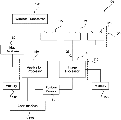
1. A system for vehicle navigation, the system comprising: a memory interface circuit; and at least one processing circuitry programmed to: receive via at least one data interface one or more images captured by one or more cameras representative of an environment of a vehicle; identify, based on analysis of the one or more images, at least one direction of at least one directional arrow on a road surface in the one or more images, wherein the at least one directional arrow is identified within a corresponding lane of the road surface, and wherein the at least one direction is identified based on at least one tip point of the at least one directional arrow represented in the one or more images; determine a direction of travel for the vehicle in the corresponding lane based on the at least one direction of the at least one directional arrow on the road surface; determine at least one navigational action for the vehicle based on the determined direction of travel for the vehicle and a planned trajectory for the vehicle that uses the corresponding lane; and cause one or more actuator systems of the vehicle to implement the determined at least one navigational action for the vehicle, wherein to identify, based on analysis of the one or more images, the at least one direction of the at least one directional arrow on the road surface in the one or more images includes to identify directions of respective directional arrows located in the corresponding lane in which the vehicle travels and located in an adjacent lane.