| CPC B60W 60/001 (2020.02) [G01C 21/3461 (2013.01); G01C 21/367 (2013.01); G06F 18/23 (2023.01); G06V 20/588 (2022.01); B60W 2420/403 (2013.01); B60W 2552/10 (2020.02); B60W 2552/53 (2020.02)] | 15 Claims |
|
1. A method, comprising:
by an electronic device of an autonomous vehicle:
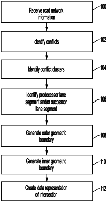
receiving a road network map that corresponds to a road network that is in an environment of the autonomous vehicle, wherein the road network map comprises a plurality of lane segments of the road network;
for each of the plurality of lane segments:
identifying one or more conflicting lane segments from the plurality of lane segments, each of which conflicts with the lane segment, and
adding conflict data pertaining to a conflict between the lane segment and the one or more conflicting lane segments to a set of conflict data;
analyzing the conflict data to identify a conflict cluster, wherein the conflict cluster comprises lane segments from the plurality of lane segments having related conflicts between or amongst them, wherein the conflict cluster is representative of an intersection;
for each lane segment in the conflict cluster:
identifying a predecessor lane segment, and
identifying a successor lane segment;
grouping the identified predecessor lane segments and the successor lane segments as inlets or outlets of the intersection;
generating an outer geometric boundary of the intersection based on a first convex hull of the lane segments in the conflict cluster, wherein the outer geometric boundary surrounds certain lane segment of the conflict cluster that define the intersection and that were not grouped as the inlets and outlets of the intersection, and wherein the outer geometric boundary encompasses a first area of the road network which is smaller than a second area of the road network including the inlets and outlets of the intersection, whereby the inlets and outlets reside outside of the outer geometric boundary;
generating an inner geometric boundary of the intersection that is different than the outer geometric boundary of the intersection and that surrounds a third area of the road network less than a total area within the intersection and being smaller than the first area of the road network which is defined by the certain lane segments of the conflict cluster, the inner geometric boundary being generated based on a second convex hull of (1) a first point on a centerline of a first lane segment in the conflict cluster which intersects a boundary line of a second lane segment in the conflict cluster at a first location, (2) a first auxiliary point located a distance from the first point in a first normal direction, (3) a second auxiliary point located a distance from the first point in a second normal direction, (4) a second point on the centerline of the first lane segment which intersects the boundary line of the second lane segment at a second different location, (5) a third auxiliary point located a distance from the second point in the first normal direction, and (6) a fourth auxiliary point located a distance from the second point in the second normal direction;
creating a data representation of the intersection that comprises:
an indication of the lane segments within the intersection;
an indication of the outer geometric boundary, and
an indication of the inner geometric boundary; and
adding the data representation to the road network map;
wherein identifying one or more conflicting lane segments from the plurality of lane segments that conflict with the lane segment comprises performing a breadth-first search or a depth-first search of the road network map.
|