| CPC G06Q 10/0833 (2013.01) [G06F 16/9535 (2019.01); G06F 16/9537 (2019.01); G06Q 10/0832 (2013.01); G11B 27/28 (2013.01); H04W 4/029 (2018.02); G06F 16/29 (2019.01); H04W 4/021 (2013.01); H04W 4/40 (2018.02)] | 20 Claims |

|
1. A method comprising:
continuously receiving location information of a carrier vehicle from one or more location sensors associated with at least one of the carrier vehicle or a mobile computing device located within the carrier vehicle, wherein the location information of the carrier vehicle corresponds to a current location of an item;
generating, by one or more computer processors, a graphical user interface, wherein the graphical user interface is configured to display a dynamic map and a dynamic icon generated using renderable map data, and the dynamic map and the dynamic icon identify the current location of the item based on the location information of the carrier vehicle; and
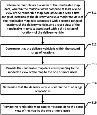
automatically updating, by the one or more computer processors and based at least in part on the location information, display of the dynamic map and the dynamic icon via multiple access views to indicate the current location of the item as the carrier vehicle moves closer to a final delivery destination for the item by:
determining the carrier vehicle is within a first range of locations;
responsive to determining the carrier vehicle is within the first range of locations, rendering a wide view of the dynamic map and the dynamic icon in a first size on the graphical user interface;
determining the carrier vehicle is within a second range of locations;
responsive to determining the carrier vehicle is within the second range of locations, rendering a moderate view of the dynamic map and the dynamic icon in a second size on the graphical user interface; and
determining the carrier vehicle is within a third range of locations; and
responsive to determining the carrier vehicle is within the third range of locations, rendering a close view of the dynamic map and the dynamic icon in a third size on the graphical user interface.
|