| CPC G01H 9/002 (2013.01) [G01S 13/86 (2013.01); G01S 13/885 (2013.01); G01V 1/003 (2013.01); G01V 3/12 (2013.01); G01V 11/00 (2013.01); G01V 2210/1299 (2013.01)] | 19 Claims |

|
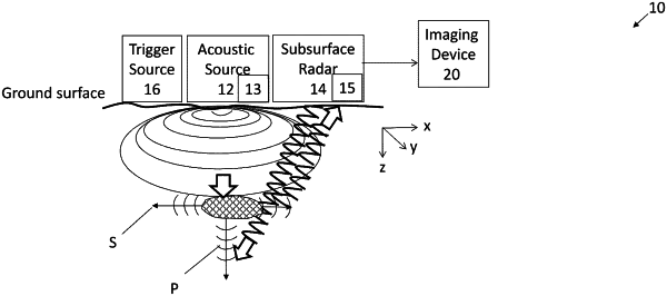
1. A system for near-surface subsurface imaging for detecting and characterizing subsurface heterogeneities, comprising:
a non-contact acoustic source that excites a plurality of propagating acoustic waves that travel through a surface at a plurality of different depths of a subsurface and at different frequencies and produces a scattered wave field in response to an insonification of subsurface features;
a radar instrument that outputs propagating electromagnetic signals through the surface that interact with and are affected by the scattered wave field of the acoustic waves and further provides one or more modalities that sense a plurality of different vibrational modes at the plurality of different depths of the subsurface;
an imaging device that communicates with the radar instrument to use a reflection of the electromagnetic signals at the plurality of different depths to dynamically generate a time sequence of images of properties of the acoustic waves interacting with the electromagnetic signals including subsurface images of scatterers of the scattered wave field, and maps elastic wave fields of the acoustic waves; and
a processor that analyzes dynamic multi-wave data of the time sequence of the images to quantify spatial variations in the mechanical and viscoelastic properties of the subsurface and uses positions of the scatterers of the scattered wave field when comparing successive images of the time sequence of images.
|