| CPC G01C 5/06 (2013.01) [G01C 25/00 (2013.01)] | 20 Claims |

|
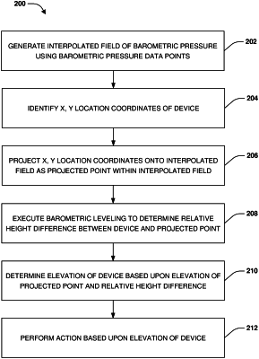
1. A method, comprising:
retrieving barometric pressure data points and elevation data points generated by a set of barometric measurement devices proximate a device;
generating an interpolated field of barometric pressure using the barometric pressure data points;
projecting x, y location coordinates of the device onto the interpolated field as a projected point within the interpolated field;
performing opportunistic calibration of the device to generate barometric pressure reading offsets;
applying the barometric pressure reading offsets to device barometric pressure values generated by the device to correct the device barometric pressure values;
executing barometric leveling upon a device barometric pressure value, of the corrected device barometric pressure values, provided by the device and a barometric pressure data point at the projected point to determine a relative height difference between the device and the projected point;
determining an elevation of the device based upon the relative height difference; and
generating at least one of a command or instructions based upon the elevation of the device.
|