| CPC G08G 5/0008 (2013.01) [B64D 45/00 (2013.01); G08G 5/0078 (2013.01); G08G 5/0091 (2013.01); B64U 10/13 (2023.01); B64U 30/20 (2023.01); B64U 50/19 (2023.01); B64U 2101/60 (2023.01); G01W 2001/003 (2013.01)] | 5 Claims |

|
1. A system comprising:
a first aircraft flying in a predetermined airspace;
a second aircraft heading to the predetermined airspace; and
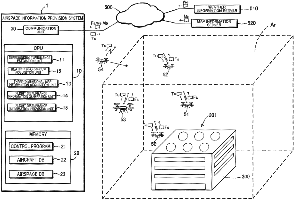
an airspace information provision server comprising a central processing unit (CPU) that functions as, by reading and executing a control program preserved in a memory:
a weather information acquisition unit configured to receive, via a communication network and from a weather information server, weather information of the predetermined airspace;
a three-dimensional map information acquisition unit configured to receive, via the communication network and from a map information server, three-dimensional map information indicating a position and a height of architecture at a lower part of the predetermined airspace and an elevation of a landform below the predetermined airspace;
a surrounding turbulence estimation unit configured to receive, from the first aircraft, flight condition information including specification information, operation information, and position information of the first aircraft via the communication network, and estimate a surrounding turbulence occurring around the first aircraft based on the flight condition information received;
a flight disturbance information generation unit configured to generate flight disturbance information indicating a disturbance element affecting the first aircraft flying in the predetermined airspace based on the surrounding turbulence occurring around the first aircraft estimated by the surrounding turbulence estimation unit, the weather information of the predetermined airspace received from the weather information server, the three-dimensional map information received from the map information server, and a wind speed near the first aircraft detected by the first aircraft; and
a flight disturbance information provision unit configured to transmit the flight disturbance information generated by the flight disturbance information generation unit to the second aircraft flying toward the predetermined airspace,
wherein the second aircraft includes an aircraft controller that is configured (i) to determine whether or not flight on an established flight route in the predetermined airspace is possible based on the flight disturbance information transmitted by the flight disturbance information provision unit, and (ii), in a case where it is determined that the flight on the established flight route is impossible, to execute an evacuation flight processing of moving the second aircraft to a position where it is possible to avoid influence of the disturbance element, or changing a flying speed of the second aircraft.
|