| CPC G06Q 50/02 (2013.01) [G06Q 10/0637 (2013.01); G01N 33/0098 (2013.01); G05B 15/02 (2013.01); G06N 20/00 (2019.01)] | 53 Claims |

|
1. An apparatus comprising:
at least one processor configured to:
obtain data measurements associated with plants in at least one growing area, the data measurements associated with one or more characteristics of the plants and one or more characteristics of the at least one growing area;
process at least some of the data measurements to identify one or more anomalous plant production issues associated with the plants, at least one of the one or more anomalous plant production issues associated with uneven production by the plants in at least part of the at least one growing area;
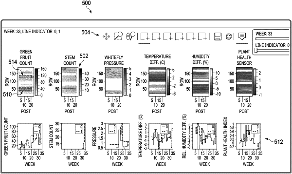
generate at least one visualization presenting at least some of the data measurements or processed versions of at least some of the data measurements in a spatial manner that corresponds to the at least one growing area, the at least one visualization identifying information associated with the one or more anomalous plant production issues and including a first visualization that includes a spatial map showing values of a specific characteristic of the plants in the at least one growing area and a second visualization displayed adjacent to the first visualization;
receive multiple selections of first graphical user interface elements displayed within multiple areas of the spatial map selecting the multiple areas of the spatial map from a user; and
in response to receiving the multiple selections of the first graphical user interface elements displayed within multiple areas of the spatial map selecting the multiple areas of the spatial map from the user:
generate second graphical user interface elements displayed within the spatial map identifying the selections of the multiple areas of the spatial map; and
populate third graphical user interface elements displayed within the second visualization with data associated with each of the multiple selected areas of the spatial map, wherein the data associated with each of the multiple selected areas of the spatial map is displayed simultaneously in the second visualization to permit comparison of different parts of the at least one growing area.
|