| CPC G05B 13/048 (2013.01) [G05B 13/042 (2013.01); G05B 23/027 (2013.01); G06F 18/20 (2023.01); G06N 7/06 (2013.01); G06Q 10/30 (2013.01); G06Q 50/02 (2013.01); G06T 17/05 (2013.01); G08B 21/12 (2013.01); G08B 31/00 (2013.01)] | 4 Claims |

|
1. A digital and intelligent operation and maintenance system for a tailings pond, comprising:
a data collection module, a data model module, an AI calculation module, a pre-judgment and warning module, an AI optimization module and a data center; wherein
the data collection module is configured to collect basic data of a tailings pond construction area, and store the basic data in the data center;
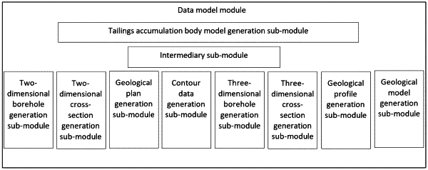
the data model module constructs a three-dimensional geological model of the tailings pond construction area and a tailings accumulation body model based on the basic data, the data model module comprising:
a two-dimensional borehole generation sub-module, configured to generate two-dimensional borehole data required for constructing the three-dimensional geological model;
a two-dimensional cross-section generation sub-module, configured to generate two-dimensional cross-section data required for constructing the three-dimensional geological model;
a geological plan generation sub-module, configured to generate a geological plan required for constructing the three-dimensional geological model;
a contour data generation sub-module, configured to generate contour data required for constructing the three-dimensional geological model;
a three-dimensional borehole generation sub-module, configured to generate three-dimensional borehole data required for constructing the three-dimensional geological model;
a three-dimensional cross-section generation sub-module, configured to generate three-dimensional cross-section data required for constructing the three-dimensional geological model;
a geological profile generation sub-module, configured to generate a geological three-dimensional profile required for constructing the three-dimensional geological model; and
a geological model generation sub-module, wherein the geological model generation sub-module supplements the geological three-dimensional profile according to the borehole data to obtain the three-dimensional geological model, the geological model generation sub-module comprises a first computer storage medium configured to generate the three-dimensional geological model, the first computer storage medium having a first computer program stored therein, and the first computer program executes the following steps when running:
generating an initial population by randomly generating chromosomes in accordance with all possible connection modes between stratum boundary points;
assessing fitness of each individual in the initial population;
sequentially performing selection, crossover and mutation operations on the population based on the set maximum number of evolutionary iterations and the fitness, and outputting the individual with the maximum fitness;
utilizing a connected-layer genetic algorithm model to obtain an optimal connection mode between stratum boundary points revealed by different boreholes; and
connecting the stratum boundary points revealed by different boreholes according to the optimal connection mode to supplement the geological three-dimensional profile, thereby creating a three-dimensional geological model;
a tailings accumulation body model generation sub-module, configured to construct the tailings accumulation body model; and
an intermediary sub-module, configured to realize data interaction between other sub-modules of the data model module other than the tailings accumulation body model generation sub-module, thereby realizing data synchronization of two-dimensional data with three-dimensional data; and
the AI calculation module is configured to calculate a pollution level of the tailings pond construction area and stability of the tailings accumulation body on the basis of the data model module, the AI calculation module comprises a second computer storage medium configured to calculate the stability of the tailings accumulation body, the second computer storage medium having a second computer program stored therein, and the second computer program executes the following steps when running:
according to the three-dimensional geological model, the tailings accumulation body model and the basic data, acquiring the stability of the tailings accumulation body by using a FLAC program and a stability calculation model, the stability calculation model satisfying the following relationship:
 wherein, S is the stability of the tailings accumulation body, Gi is the gravity of an i-th soil bar in the tailings accumulation body, α1 is the value of an angle between a connecting line of a midpoint of a sliding surface of the i-th soil bar and the center of a circle corresponding to the sliding surface of the soil bar and a vertical line, φi is the effective cohesion of a bottom surface of the i-th soil bar, ρi+1 is a moment correlation coefficient between the i-th soil bar and an i+1-th soil bar, n is the total number of soil bars, ci is the cohesion of the i-th soil bar, and li is the length of the i-th soil bar along the sliding surface; and
determining the pollution level by using a GWO-SVM model based on the basic data and the stability;
the pre-judgment and warning module performs pollution warning by using the pollution level, and performs stability warning according to the stability;
the AI optimization module is configured to, on the basis of the data model module and the pre-judgment and warning module, analyze and output an optimal discharge mode of the tailings accumulation body according to a set optimized tailings accumulation body model, and discharge according to the optimal discharge mode; and
the data center is configured to receive and store data generated by each module, and realize information sharing between the modules.
|