| CPC G01W 1/10 (2013.01) | 16 Claims |

|
1. A method performed by an electronic device for predicting snowmelt flood, comprising:
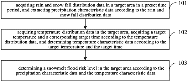
acquiring rain and snow fall distribution data in a target area in a preset time period, and extracting precipitation characteristic data according to the rain and snow fall distribution data;
acquiring temperature distribution data in the target area, acquiring a target temperature and a corresponding target time according to the temperature distribution data, and determining temperature characteristic data according to the target temperature and the target time;
determining a snowmelt flood risk level in the target area according to the precipitation characteristic data and the temperature characteristic data; and
generating an animation to simulate a future snowmelt flood in the target area according to the snowmelt flood risk level;
wherein acquiring the temperature distribution data in the target area comprises:
acquiring a plurality of station temperatures collected by a plurality of weather stations in the target area in the preset time period; and
performing interpolation on the plurality of the station temperatures according to an inverse distance weighted interpolation algorithm to generate temperature distribution raster data in the target area in the preset time period;
wherein performing interpolation on the plurality of the station temperatures according to the inverse distance weighted interpolation algorithm to generate temperature distribution raster data in the target area in the preset time period comprises:
performing interpolation on the plurality of the station temperatures by an interpolation formula to generate the temperature distribution raster data in the target area in the preset time period, wherein the interpolation formula is:
 where Z represents a temperature at a point after interpolation, Zi represents a temperature at an ith weather station, di represents a distance between the ithweather station and the point to be interpolated, m represents a distance factor, hirepresents a height of the ith weather station, h represents a height of the point to be interpolated, and n represents the number of weather stations.
|