| CPC G01C 21/3807 (2020.08) [B60W 40/06 (2013.01); B60W 40/076 (2013.01); G01S 7/4802 (2013.01); G06V 10/80 (2022.01); G06V 20/588 (2022.01); B60W 50/14 (2013.01); B60W 2420/403 (2013.01); B60W 2420/408 (2024.01); B60W 2510/222 (2013.01); B60W 2530/201 (2020.02); B60W 2552/15 (2020.02); B60W 2552/35 (2020.02); B60W 2552/45 (2020.02); B60W 2555/20 (2020.02); B60W 2556/40 (2020.02); B60W 2710/18 (2013.01); B60W 2710/20 (2013.01)] | 20 Claims |
|
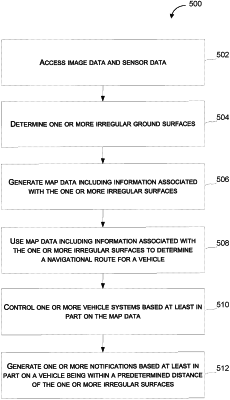
1. A computer-implemented method of mapping, the computer-implemented method comprising:
accessing, by a computing system comprising one or more processors, image data and sensor data, wherein the image data comprises a plurality of images of one or more locations and semantic information associated with the one or more locations, and wherein the sensor data comprises sensor information associated with three-dimensional features of one or more surfaces based on detection of the one or more surfaces at the one or more locations by one or more sensors;
determining, by the computing system, one or more irregular surfaces based at least in part on the image data and the sensor data, wherein the one or more irregular surfaces comprise the one or more surfaces associated with the image data and the sensor data that satisfy one or more irregular surface criteria at each of the one or more locations respectively, wherein satisfying the one or more irregular surface criteria comprises the three-dimensional features indicating that the one or more surfaces exceed a surface area threshold and include a depression that exceeds a depth threshold;
generating, by the computing system, map data comprising information associated with the one or more irregular surfaces; and
controlling, by the computing system, one or more vehicle systems of a vehicle based at least in part on the map data, wherein the one or more vehicle systems comprise one or more motor systems.
|