| CPC E21B 49/005 (2013.01) [E21B 49/003 (2013.01); G01V 1/50 (2013.01)] | 12 Claims |

|
1. A method, comprising:
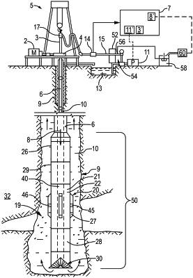
drilling a wellbore via drilling operations of a drilling rig system;
sampling cuttings from the drilling operations via a sampler;
measuring with one or more sensors during the drilling operation measurements of a characteristic comprising gamma ray count, formation strength, and total gas in mud, wherein the measurements are based on cuttings obtained by the sampler;
identifying a first set of change points in a first measurement log of the measurements of cutting percentage as a function of a depth of the wellbore based on the cuttings obtained by the sampler during the drilling operations of the drilling rig system, wherein each change point of the first set of change points corresponds to a respective identified trend change in the measurements of the cutting percentage along the depth of the wellbore;
identifying a second set of change points in a second measurement log of the measurements of the characteristic as a function of the depth of the wellbore based on input obtained by the one or more sensors during the drilling operations of the drilling rig system, wherein each change point of the second set of change points corresponds to a respective identified trend change in the measurements of the characteristic along the depth of the wellbore;
segmenting the wellbore into a plurality of regions based on the first set of change points and the second set of change points;
sub-segmenting a first region of the plurality of regions into a plurality of zones based on one or more rock types being detected in the first measurement log;
determining respective locations, lengths, and rock types of one or more layers in a first zone of the plurality of zones based on a total percentage of each of the one or more rock types in the first zone during the drilling operations; and
automatically generating a representation showing an interpreted lithology log in real time during the drilling operations for decision-making regarding the drilling operations, wherein the representation of the interpreted lithology log shows a sequence of the one or more layers as the function of the depth based on the determined respective locations, lengths, and rock types of the one or more layers in the first zone of the plurality of zones, and the first zone visible in the representation of the interpreted lithology log is aligned with a zone in a representation of mineralogy.
|