| CPC G06F 16/838 (2019.01) [G06F 16/81 (2019.01); G06F 16/909 (2019.01)] | 20 Claims |

|
1. A method performed by a system to generate a multilayer geographical virtualization, wherein the method comprises:
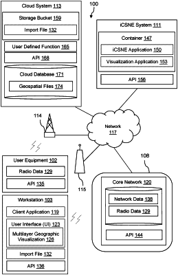
receiving, by an application of the system, a request to generate the multilayer geographical virtualization based on a first import file received from a first user as multiple subfiles and a second import file received from a second user different from the first user and formatted as a keyhole markup language (KML) file, wherein the first import file and the second import file are first stored at a scalable storage bucket in a cloud system;
responsive to receiving the request, performing processing, via a user defined function at the cloud system, to:
process the subfiles to provide the first import file formatted as a Shapefile;
process the first import file to obtain a first geospatial file by translating the first import file from a first file format to a third file format and normalizing data of the first import file appearing in the third file format, wherein the third file format is a common format for geospatial files;
process the second import file to obtain a second geospatial file by translating the second import file from a second file format to the third file format and normalizing data of the second import file appearing in the third file format; and
transmit the first geospatial file and the second geospatial file to a cloud database for storage;
responsive to completion of the processing by the user defined function, fetching, by the application, the first geospatial file from the cloud database;
generating, by a visualization application of the system, a first layer of the multilayer geographical virtualization based on the first geospatial file fetched from the cloud database;
fetching, by the application, the second geospatial file from the cloud database;
adding, by the visualization application, a second layer to the multilayer geographical virtualization based on the second geospatial file fetched from the cloud database; and
transmitting, by the visualization application to a workstation, the multilayer geographical virtualization for display at the workstation.
|