| CPC E21B 43/16 (2013.01) [G06T 17/05 (2013.01); E21B 2200/20 (2020.05)] | 8 Claims |

|
1. A method for updating a three-dimensional lithology model for precision navigation of deep oil and gas in real time, comprising:
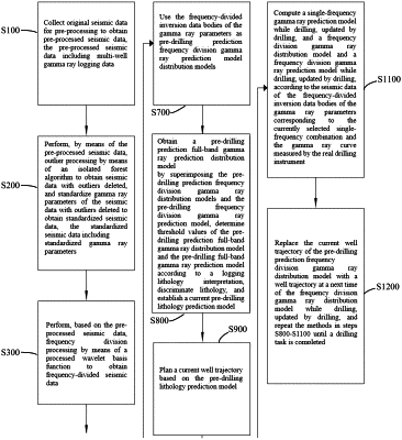
step S100, collecting original seismic data and original logging data, and pre-processing the original seismic data to obtain pre-processed seismic data, the original logging data comprising multi-well gamma ray logging data;
step S200, performing, based on the original logging data, outlier processing by means of an isolated forest algorithm to obtain logging data with outliers deleted, the logging data with the outliers deleted comprising gamma ray parameters with outliers deleted; and
standardizing the logging data with the outliers deleted to obtain standardized logging data, the standardized logging data comprising standardized gamma ray parameters;
step S300, performing, based on the pre-processed seismic data, frequency division processing by means of a processed wavelet basis function to obtain frequency-divided seismic data, the frequency-divided seismic data comprising three types of single-frequency seismic waveform data, i.e., low-frequency seismic data, intermediate-frequency seismic data, and high-frequency seismic data,
wherein a method for obtaining the frequency-divided seismic data comprises:
designing, according to the pre-processed seismic data, a processed wavelet basis function better matching with the pre-processed seismic data based on a Mollet wavelet basis function:
 wherein ψg represents the wavelet basis function, t represents a time, k represents a variable making the processed wavelet basis function satisfy a normalization condition, σ represents an interval of a time-frequency two-dimensional resolution, μ represents a constant controlling a center position of a frequency after wavelet transformation, ω represents an imaginary unit, π represents a circular constant, and e represents a natural constant;
letting the processed wavelet basis function satisfy the normalization condition ∥ψg∥2=1, and there is
 inputting all seismic channel data, and performing frequency division transformation on a seismic channel by means of the processed wavelet basis function to obtain the frequency-divided seismic data Wg:
 a represents a scale factor, b represents a time-shift factor, Wg(a,b) represents amplitude values of a specific frequency a and a specific time b, fp represents a frequency of a wavelet basis, k2 represents a variable making the processed wavelet basis function satisfy a normalization condition, and α and β are distributed parameters in normal distribution
 respectively, wherein N represents a normal distribution;
step S400, determining a time window top three-dimensional curved surface and a time window bottom three-dimensional surface of a stratum according to a three-dimensional surface of a target horizon and visual seismic data;
step S500, obtaining a clustering result of single-frequency seismic waveform data in a time window of the stratum by means of a clustering algorithm according to the frequency-divided seismic data and the time window top three-dimensional curved surface and the time window bottom three-dimensional surface of the stratum;
step S600, obtaining frequency-divided inversion data bodies of the gamma ray parameters by performing a waveform indication inversion algorithm on the clustering result of the single-frequency seismic waveform data in the time window of the stratum, the standardized gamma ray parameters and clustering results of a corresponding well depth, well location information and single-frequency seismic waveform data in the time window of the stratum of the standardized gamma ray parameters;
step S700, using the frequency-divided inversion data bodies of the gamma ray parameters as pre-drilling prediction frequency division gamma ray distribution models;
step S800, obtaining a pre-drilling prediction full-band gamma ray distribution model by superimposing the pre-drilling prediction frequency division gamma ray distribution models corresponding to low-frequency, intermediate-frequency and high-frequency, determining a threshold value of the pre-drilling prediction full-band gamma ray distribution model according to a logging lithology interpretation, discriminating lithology based on the threshold value, and establishing a current pre-drilling lithology prediction model based on the discriminated lithology;
step S900, planning a current well trajectory based on the pre-drilling lithology prediction model;
step S1000, extracting a three-dimensional coordinate of the current well trajectory, and extracting a borehole-side pre-drilling full-band gamma ray prediction curve or a frequency division gamma ray prediction curve while drilling from the pre-drilling full-band gamma ray distribution model based on the three-dimensional coordinate, computing a correlation coefficient between the borehole-side pre-drilling full-band gamma ray prediction curve and a gamma ray curve measured by a real drilling instrument, or a correlation coefficient between the frequency division gamma ray prediction curve while drilling and the gamma ray curve measured by the real drilling instrument, and selecting a combination of the single-frequency seismic waveform data with the highest correlation coefficient as a currently selected combination of the single-frequency seismic waveform data;
step S1100, computing a frequency division gamma ray distribution model while drilling, updated by drilling, according to the frequency-divided inversion data bodies of the gamma ray parameters corresponding to the currently selected combination of the single-frequency seismic waveform data and the gamma ray curve measured by the real drilling instrument; and
step S1200, replacing the pre-drilling prediction frequency division gamma ray distribution model with the frequency division gamma ray distribution model while drilling, updated by drilling, and repeating the methods in steps S800-S1100 until a drilling task is completed.
|