| CPC G06F 30/13 (2020.01) [G06F 18/214 (2023.01); G06F 18/22 (2023.01); G06N 5/04 (2013.01); G06N 20/00 (2019.01); G06T 7/70 (2017.01); G06T 17/05 (2013.01); G06V 10/44 (2022.01); G06V 10/764 (2022.01); G06V 10/774 (2022.01); G06V 20/176 (2022.01); G06V 20/64 (2022.01); G06T 2200/08 (2013.01); G06T 2200/24 (2013.01); G06T 2207/20081 (2013.01); G06T 2207/30184 (2013.01)] | 19 Claims |
|
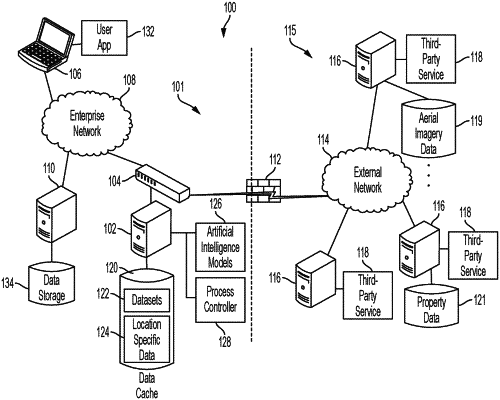
1. A method, comprising:
applying, by a processing system, a building detection model to identify a footprint of a building based on a first dataset;
applying, by the processing system, a building characterization model to identify one or more derived characteristics of the building based on the footprint;
determining, by the processing system, a building area based on the footprint and at least one of the one or more derived characteristics of the building;
creating, by the processing system, a record comprising an indicator of a geographic area, the building area, and the one or more derived characteristics of the building;
generating, by the processing system, a processing request based on the record;
accessing, by the processing system, a third-party data source comprising a plurality of property data associated with the geographic area;
determining, by the processing system, a plurality of property boundaries associated with the building based on the property data;
identifying, by the processing system, one or more property features within the property boundaries based on the first dataset;
comparing, by the processing system, the one or more derived characteristics of the building with one or more corresponding values of the property data;
identifying, by the processing system, a mismatch between the one or more derived characteristics of the building and the one or more corresponding values of the property data; and
outputting, by the processing system, a data accuracy verification request based on the mismatch.
|