| CPC G05B 13/048 (2013.01) [A01B 79/005 (2013.01); A01B 79/02 (2013.01); G06F 17/18 (2013.01)] | 20 Claims |
|
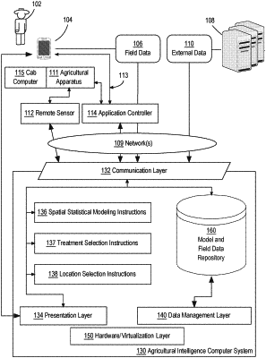
1. A system comprising:
one or more processors;
a memory storing instructions which, when executed by the one or more processors, causes performing:
receiving first yield data for a first portion of an agronomic field, the first portion of the agronomic field subjected to a first treatment;
receiving second yield data for a second portion of the agronomic field, the second portion of the agronomic field subjected to a second treatment that is different than the first treatment;
using a spatial statistical model, computing a yield value, per location, for the second portion of the agronomic field based on a vector of covariate(s) and the first yield data, the vector of covariate(s) indicative of one or more measurable properties of the agronomic field per location, the yield value indicating an agronomic yield for the second portion of the agronomic field had the second portion of the agronomic field been subject to the first treatment;
determining, per location of the second portion of the agronomic field, a difference between the computed yield value and the second yield data;
selecting the second treatment based on the difference relative to a threshold; and
generating a prescription map based on the spatial statistical model, the prescription map including the second treatment applied to a portion of a field, which is larger than the second portion of the agronomic field.
|