| CPC G01S 19/14 (2013.01) [G01C 21/1656 (2020.08); G01S 5/0027 (2013.01); G01S 19/47 (2013.01); G01S 19/485 (2020.05); G01S 19/49 (2013.01); G06F 18/25 (2023.01); G06V 20/20 (2022.01)] | 20 Claims |
|
1. A method implemented by a data fusing device, wherein the method comprises:
orientating a series of images of a scene to provide orientated images;
generating a 3D reconstruction of the scene using the orientated images;
defining an arbitrary local coordinate system;
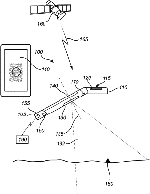
determining a first set of positions from which at least some of the series of images have been captured in the local coordinate system, the series of images captured using a portable positioning device;
obtaining a second set of positions corresponding to geospatial positions of the portable positioning device in a global coordinate system for said at least some of the series of images, the second set of positions determined using the portable positioning device;
determining a transformation function correlating a position of a point in the global coordinate system with a position of the point in the local coordinate system based on a known spatial position of a point from which an image of the series of images has been captured by the portable positioning device relative to the point at which the geospatial positions of the portable positioning device are obtained for said at least some of the series of images, the first set of positions, and the second set of positions;
identifying a point of interest in the generated 3D reconstruction of the scene;
determining the position of the point of interest in the local coordinate system; and
determining a geospatial position of the point of interest in the global coordinate system based on the determined position of the point of interest in the local coordinate system and the determined transformation function.
|