| CPC B60W 40/076 (2013.01) [B60W 40/072 (2013.01); B60W 50/0097 (2013.01); B60W 2420/42 (2013.01); B60W 2552/15 (2020.02); B60W 2556/40 (2020.02)] | 20 Claims |
|
1. A method comprising:
obtaining sensor data from one or more sensors onboard a vehicle, the sensor data including camera data from one or more cameras onboard the vehicle;
obtaining location data pertaining to a location of the vehicle;
receiving user inputs as to a destination of travel for the vehicle;
obtaining map data pertaining to a path corresponding to the location and the destination of travel;
generating, using a processor onboard the vehicle, a planned mission for travel to the destination along a roadway associated with the path, based on the user inputs, the location data, and the map data;
generating, using the processor, a planned mission for travel to the destination along a roadway associated with the path, based on the user inputs and the location data;
generating, using the processor, an elevation profile along the path using the sensor data, including the camera data, and the map data, by generating the road elevation profile over a receding prediction horizon for the roadway for a plurality of time points for travel of the vehicle along the roadway in accordance with the planned mission, using both the sensor data and the map data; and
proactively controlling the vehicle, based on instructions provided by the processor, using the predicted elevation profile, for adjusting each of the following: acceleration, steering, and braking of the vehicle along the receding prediction horizon for the roadway for a plurality of time points for travel of the vehicle along the roadway in accordance with the planned mission,
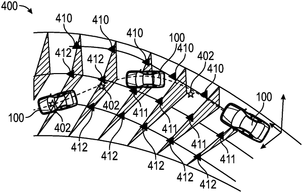
wherein the road elevation profile comprises a plurality of bank and grade angle data points that are obtained at different lanes and segments along the roadway, the bank and grade angle data points including: (i) first bank and grade angle data points along a first lane of the of the roadway in which the vehicle is currently travelling; (ii) second bank and grade angle data points corresponding to a second lane of the roadway comprising an immediately adjacent lane to the first lane; and (iii) third bank and grade angle data points along a third lane of the roadway that is two lanes away from the first lane.
|