| CPC G06V 20/188 (2022.01) [G06T 7/0002 (2013.01); G06V 20/38 (2022.01); H04W 4/025 (2013.01); H04W 4/029 (2018.02); G06Q 50/02 (2013.01); G06T 2207/10032 (2013.01); G06T 2207/30188 (2013.01)] | 1 Claim |
|
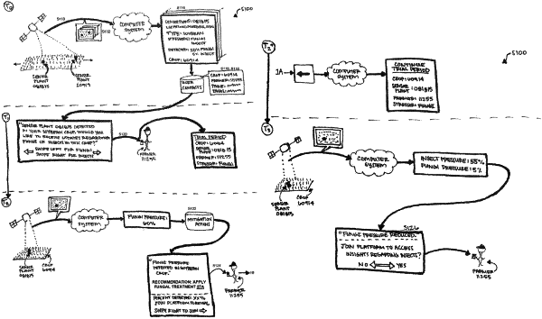
1. A method comprising:
accessing a feed of images recorded at a set frequency by an aerial sensor;
during an initial period:
detecting a signal generated by a sensor plant in a subset of images in the feed of images, the sensor plant configured to generate an optical signal indicating presence of a set of stressors;
identifying a geographic location of the sensor plant based on the subset of images;
identifying a user associated with a crop located within a threshold distance of the geographic location; and
flagging the user for recruiting to join a sensor plant platform; and
during a trial period succeeding the initial period:
at a first time, in response to detecting a first pressure of a first stressor, in the set of stressors, at the sensor plant, notifying the user of presence of the first stressor in the crop;
at a second time, in response to detecting a second pressure of the first stressor at the sensor plant, the second pressure exceeding a threshold pressure:
identifying a first mitigation action, in a set of mitigation actions, predicted to reduce the second pressure of the first stressor; and
notifying the user of the second pressure of the first stressor and the first mitigation action; and
at a third time, in response to detecting a first pressure of a second stressor, in the set of stressors, prompting the user to join the sensor plant platform to gain access to information regarding the second stressor in the crop.
|