| CPC G06T 17/05 (2013.01) [G06T 3/4038 (2013.01)] | 19 Claims |

|
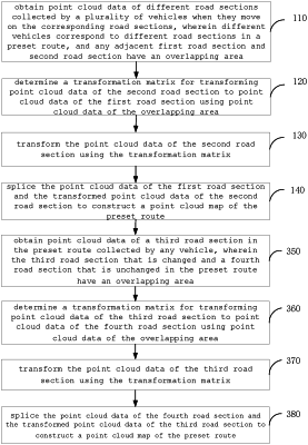
1. A method for cooperatively constructing point cloud map, comprising:
obtaining point cloud data of different road sections respectively collected by a plurality of vehicles when they move on the corresponding road sections, wherein different vehicles correspond to different road sections in a preset route, and any adjacent first road section and second road section have an overlapping area;
determining a transformation matrix for transforming point cloud data of the second road section to point cloud data of the first road section using point cloud data of the overlapping area;
transforming the point cloud data of the second road section using the transformation matrix;
splicing the point cloud data of the first road section and the transformed point cloud data of the second road section to construct a point cloud map of the preset route;
obtaining point cloud data of a third road section in the preset route collected by any vehicle, wherein the third road section that is changed and a fourth road section that is unchanged in the preset route have an overlapping area;
determining a transformation matrix for transforming point cloud data of the third road section to point cloud data of the fourth road section using point cloud data of the overlapping area;
transforming the point cloud data of the third road section using the transformation matrix;
splicing the point cloud data of the fourth road section and the transformed point cloud data of the third road section to construct a point cloud map of the preset route.
|