| CPC G01V 3/18 (2013.01) [E21B 49/00 (2013.01); G01V 3/38 (2013.01)] | 30 Claims |

|
1. A method for determining an original stratum direction of a core, which is performed by using an apparatus for determining an original stratum direction of a core,
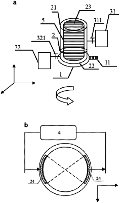
wherein the apparatus comprising a core holder, a first confining pressure pump and a resistance meter, wherein,
the core holder consists of an upper half part and a lower half part, wherein the upper half part is configured for accommodating a core, the lower half part is configured for accommodating and fixing the core, and sides of the upper half part and the lower half part are respectively provided with scales for determining a rotation angle of the core,
the first confining pressure pump is configured for pressurizing the upper half part of the core holder, and
the resistance meter is configured for measuring an electrical resistance value of the core;
wherein the method comprises:
step one: displacing water in the core with saturated water by gas until the saturated water in the core reaches the original stratum water saturation;
step two: putting the core which is in a stratum water saturation state into the lower half part of the core holder and fixing the core, then covering the top of the core with the upper half part of the core holder, recording an angle difference between a scale of the upper half part of the core holder and a scale of the lower half part of the core holder at this time, and marking a position of the core at this time;
step three: rotating the lower half part of the core holder and the core at an appropriate angle with the upper half part of the core holder being fixed, recording a rotation angle of the core, and measuring an electrical resistance value of the core;
step four: repeating step three until the core rotates 360° in total; finding the rotation angles θmax and θmin respectively corresponding to maximum electrical resistance value Rmax and minimum electrical resistance value Rmin of the core, rotating the core at the rotation angles θmax and θmin, and marking corresponding positions on the core as max and min respectively; and
step five: finding the darkest and brightest positions in terms of imaging color near a coring depth in resistivity imaging logging data, corresponding geographic information of the darkest and brightest positions to the positions represented by max and min on the core respectively, and determining the original stratum direction of the core.
|