| CPC G06V 20/10 (2022.01) [G01C 21/3822 (2020.08); G01C 21/3841 (2020.08); G01C 21/3859 (2020.08); G06F 18/251 (2023.01); G06V 10/803 (2022.01); G06V 20/56 (2022.01)] | 18 Claims |

|
1. A computer-implemented method comprising:
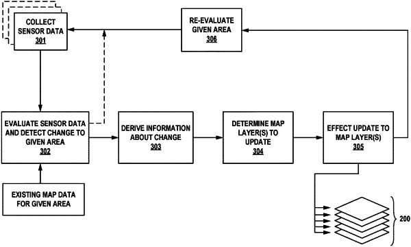
maintaining a map that is representative of a real-world environment, the map comprising a plurality of layers, wherein each layer of the map is encoded with a different type of map data;
obtaining sensor data that is indicative of a given area of the real-world environment;
based on an evaluation of (i) the obtained sensor data and (ii) map data corresponding to the given area, detecting that a change has occurred in the given area involving an addition of a new semantic feature to the given area of the real-world environment;
based on the obtained sensor data, deriving information about the detected change to the given area, wherein the derived information about the detected change to the given area includes at least a type of the detected change and a location of the detected change;
based on the derived information about the detected change, determining that multiple different layers of the map are impacted by the detected change, wherein the multiple different layers comprise a semantic map layer that is encoded with semantic map data and at least one of a geometric map layer or a priors layer; and
effecting an update to the multiple different layers of the map based on the derived information about the detected change.
|