| CPC G06F 3/04817 (2013.01) [G06F 3/0482 (2013.01); G06F 3/04842 (2013.01); G06F 3/0488 (2013.01); G06F 16/248 (2019.01); G06F 16/29 (2019.01); G06F 16/487 (2019.01); G06F 16/9535 (2019.01); G06F 16/9537 (2019.01); G06Q 50/01 (2013.01); G06T 11/206 (2013.01); G06T 11/60 (2013.01); H04L 41/22 (2013.01); H04L 41/28 (2013.01); H04L 51/52 (2022.05); H04L 63/101 (2013.01); H04L 63/107 (2013.01); H04L 67/12 (2013.01); H04L 67/306 (2013.01); H04L 67/52 (2022.05); H04L 67/535 (2022.05); H04W 4/02 (2013.01); H04W 4/029 (2018.02); H04W 4/185 (2013.01); H04W 4/21 (2018.02); H04W 12/02 (2013.01); G06F 9/547 (2013.01); G06T 2200/24 (2013.01)] | 18 Claims |

|
1. A method comprising:
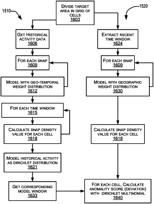
generating a model of social media activity in a geographical area in an automated procedure performed using one or more computer processor devices configured therefor, the generating of the social media activity model comprising:
for each of multiple social media postings forming part of the social media activity, representing the posting as having a respective density distribution in two-dimensional space; and
calculating a geographical distribution of posting density in the geographical area by summing, at each of multiple positions within the geographical area, respective density contributions of each posting whose density distribution at least partially overlaps the respective position;
based on the social media activity model, calculating one or more attributes of the social media activity in the geographical area;
based at least in part on the one or more calculated attributes, identifying one or more user interface elements for display with respect to the geographical area;
causing display on a client device of a graphical user interface (GUI) for a social media platform, the GUI comprising:
an interactive map representative of at least the geographical area; and
the one or more identified user interface elements overlaid on the interactive map.
|