| CPC G01N 33/0098 (2013.01) [A01G 7/00 (2013.01); A01G 13/06 (2013.01); A01G 25/16 (2013.01); A01M 21/043 (2013.01); G01D 11/30 (2013.01); G05B 15/02 (2013.01); G06N 5/04 (2013.01); G06N 20/00 (2019.01); G08C 17/02 (2013.01)] | 20 Claims |

|
1. A method comprising:
receiving, using at least one processor, sensor data pertaining to each of multiple plants in a growing area, the sensor data received from a mobile sensory platform that includes (i) a propulsion system configured to move the mobile sensory platform within the growing area and (ii) multiple sensors configured to capture the sensor data associated with the multiple plants;
processing the sensor data using a predictive model in order to identify one or more issues affecting each of at least one of the plants;
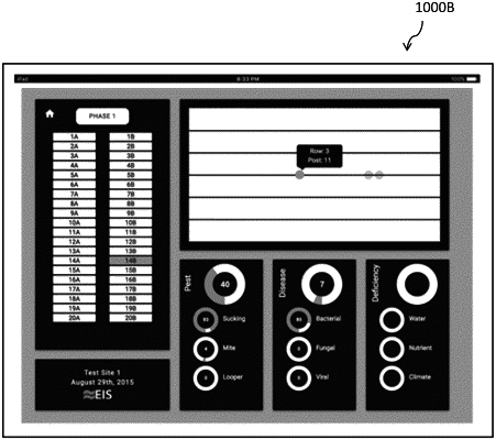
generating a graphical user interface that includes a graphical representation of the growing area, the graphical representation identifying individual rows in the growing area;
identifying, using one or more markers in the graphical representation of the growing area, one or more of the at least one of the plants having the one or more issues, each of the one or more markers positioned along one of the individual rows identified in the graphical representation at a location of the associated plant, each of the one or more markers being selectable by a user;
receiving a selection of a specified marker among the one or more markers from the user; and
in response to the selection of the specified marker, presenting information related to the plant associated with the specified marker in the graphical user interface, the information identifying the one or more issues affecting the plant associated with the specified marker;
wherein at least some of the sensor data relates to a three-dimensional (3D) structure of each of the plants.
|