| CPC G01C 21/3822 (2020.08) [G01C 21/3841 (2020.08); G01C 21/3878 (2020.08)] | 20 Claims |

|
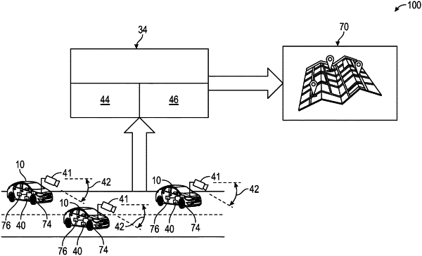
1. A method of creating a high-definition (HD) map of a roadway, comprising:
receiving sensor data from a plurality of sensors of a plurality of vehicles, wherein the sensor data includes vehicle GPS data received from a plurality of GPS transceivers of the plurality of vehicles, and the sensor data includes sensed lane line data of the roadway received from a plurality of cameras from the plurality of vehicles;
creating a plurality of multi-layer bitmaps for each of the plurality of vehicles using the sensor data;
fusing the plurality of the multi-layer bitmaps of each of the plurality of vehicles to create a fused multi-layer bitmap;
creating a plurality of multi-layer probability density bitmaps using the fused multi-layer bitmap;
extracting lane line data from the plurality of multi-layer probability density bitmaps to obtain extracted lane line data; and
creating the HD map of the roadway using the multi-layer probability density bitmaps and the extracted lane line data from the plurality of multi-layer probability density bitmaps, wherein the HD map of the roadway includes a plurality of lane lines of each of the plurality of lanes of the roadway, thereby improving vehicle navigational technology; and
showing the HD map on a display of a host vehicle.
|
|
11. A tangible, non-transitory, machine-readable medium, comprising machine-readable instructions, that when executed by one or more processors, cause the processors to:
receive sensor data from a plurality of sensors of a plurality of vehicles, wherein the sensor data includes vehicle GPS data received from a plurality of GPS transceivers from the plurality of vehicles, and the sensor data includes sensed lane line data of a roadway received from a plurality of cameras of the plurality of vehicles;
create a plurality of multi-layer bitmaps for each of the plurality of vehicles using the sensor data;
fuse the plurality of the multi-layer bitmaps of each of the plurality of vehicles to create a fused multi-layer bitmap;
create a plurality of multi-layer probability density bitmaps using the fused multi-layer bitmap;
extract lane line data from the plurality of multi-layer probability density bitmaps to obtain extracted lane line data; and
create a high-definition (HD) map of the roadway using the multi-layer probability density bitmaps and the extracted lane line data from the plurality of multi-layer probability density bitmaps, wherein the HD map of the roadway includes a plurality of lane lines of each of the plurality of lanes of the roadway, thereby improving vehicle navigational technology; and
showing the HD map on a display of a host vehicle.
|