| CPC B60W 60/0011 (2020.02) [G05D 1/0088 (2013.01); G05D 1/0251 (2013.01); G06F 18/2415 (2023.01); G06T 7/33 (2017.01); G06V 10/7715 (2022.01); G06V 20/58 (2022.01); G06V 20/588 (2022.01); G01S 17/894 (2020.01); G05D 2201/0213 (2013.01); G06T 2207/10028 (2013.01); G06T 2207/30256 (2013.01); G06T 2207/30261 (2013.01)] | 25 Claims |
|
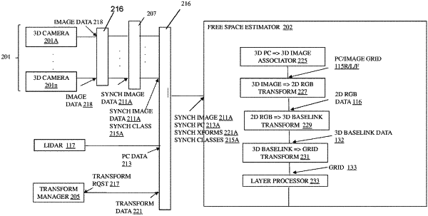
1. A method for estimating free space based on image data and point cloud data, the free space used for navigating an autonomous vehicle, the method comprising:
semantically classifying the image data based on a machine learning model forming point classifications and point classification probabilities;
associating each point in the point cloud data to the image data that are spatially co-located with the point cloud data;
classifying each of the points as an obstructed space or a non-obstructed space based on the spatial association of each of the points with the semantically classified image data forming obstructed points and non-obstructed points;
forming a grid of the obstructed points and non-obstructed points within a pre-selected area surrounding the autonomous vehicle; and
estimating the free space in the pre-selected area by associating the obstructed points with a first probability based at least on (1) noise in the point cloud data, (2) a second probability that the point cloud data are reliable, (3) a distance from the non-obstructed points to the obstructed space closest to the non-obstructed points, (4) a third probability that the point classifications are correct, and (5) presence of the non-obstructed space.
|