| CPC G01V 3/081 (2013.01) [G01V 3/15 (2013.01); G01V 3/165 (2013.01); G01V 15/00 (2013.01)] | 22 Claims |
|
1. A system for electronically marking buried utilities, comprising:
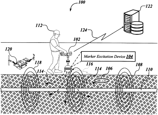
an electronic marker device placed below a ground surface in proximity to a buried utility;
a buried utility locator including:
a marker excitation device to generate and provide a marker excitation signal to the electronic marker device;
a locator front-end subsystem to receive a marker response signal from the electronic marker device responsive to the marker excitation signal and magnetic field signals emitted from the buried utility; and
a locator processing element to process the received marker response signal obtained from the electronic marker device to generate marker device data indicative of identity and/or position of the placed electronic marker device, and further process the magnetic field signals obtained from the buried utility locator to generate utility data indicative of position of the buried utility relative to the ground surface;
a remote computing device communicatively coupled to the buried utility locator, including a remote computing device processing element and an association module coupled to the remote computing device processing element, the association module being configured to receive the generated marker device data and the utility data from the buried utility locator, associate the marker device data to the utility data, and store the associated marker device data and the utility data into a non-transitory memory associated with the remote computing device such that the utility data is retrievable from the non-transitory memory based in part on the marker device data; and
a display unit for virtually displaying the buried utility based on the utility data associated with the buried utility locator, wherein the position of the buried utility is updated in real-time based on corresponding movements of the buried utility locator above the ground surface.
|