| CPC B60W 40/06 (2013.01) [B60W 2420/42 (2013.01); B60W 2420/52 (2013.01); B60W 2554/4041 (2020.02); G01S 13/885 (2013.01); G01V 3/12 (2013.01); G01V 3/15 (2013.01)] | 10 Claims |
|
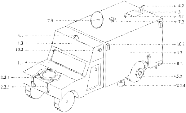
1. A vehicle-mounted equipment for rapid detection of danger and hidden danger of a dike, wherein the equipment comprises:
an operation vehicle;
an operation shelter, located behind the cockpit of the operation vehicle and arranged on the chassis of the operation vehicle;
a detection system, including a ground penetrating radar detection module, a transient electromagnetic detection module and a seismic wave detection module to perform physical detection of the dike, respectively; wherein the ground penetrating radar detection module is mounted behind the operation vehicle by a towing device; and the transient electromagnetic detection module being mounted in front of the operation vehicle by a support device;
a marking device, mounted below the tail of the operation shelter and used for marking dike sections with hidden danger/danger;
a scanning system, comprising a laser radar module and a lifting module, wherein the lifting module is mounted at the tail end of the top of the operation shelter, and the laser radar module being fixed on the lifting module, moving with the operation vehicle and scanning the dike surface;
a video recording system, for video-recording the environment around the operation vehicle;
a positioning system, including a positioning module mounted on the top of the operation shelter, wherein the positioning module transmits positioning information synchronously to the detection system, the scanning system, the video recording system and a data processing system; and the positioning system further comprising a deviation correction module to position and correct detection components;
the data processing system, including a server mounted inside the operation shelter and a display device connected to the server, wherein the server receives and processes data transmitted by the detection system, the scanning system and the positioning system; the server containing a typical atlas library of ground penetrating radar and transient electromagnetic detection results, including digital detection atlases of four typical dikes:
hollow, uncompacted, seeping and normal, and during data processing, the server invoking the typical atlas library and studying and judging the hidden danger obtained from detection by the method of intelligent image identification;
the data processing including:
(i) for the data acquired by the detection system, adopting the detection results within 5 m below the detection surface detected by the ground penetrating radar detection module in real time and abandoning the data signals above 5 m; adopting the detection results 5m˜30 m below the detection surface detected by the transient electromagnetic module in real time;
and adopting the elastic wave velocity information of dike sections detected by the seismic wave detection module by sections, and determining weak dike sections based on dike section wave velocity Vs<140 m/s;
(ii) constructing a twin 3 D model of the dike through the point cloud data and real images sent back by the scanning system and the video recording system;
(iii) determining the positions of the areas with hidden danger inside the dike found during general inspection in combination with the position information returned by the positioning system, and visually displaying the areas with hidden danger in combination with the twin 3 D model; and displaying in real time the position of the operation vehicle in combination with an electronic map;
(iv) visually displaying the processing results of the server by the display device;
a communication system, used for communication of systems/devices inside the vehicle and/or for remote communication with external devices;
a control system, connected to the detection system and the scanning system and used for operation control; and
a power distribution module, mounted on the operation vehicle and supplying power to electric devices.
|