| CPC G01B 5/18 (2013.01) [G01V 1/46 (2013.01); G01V 1/50 (2013.01)] | 20 Claims |

|
1. A computer-implemented method comprising:
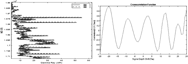
while a wireline tool is moving within a wellbore, receiving (i) a first set of sensor data generated by a first sensor of the wireline tool, and (ii);
a second set of sensor data generated by a second sensor of the wireline tool, wherein the first set of sensor data includes a first pattern recorded by the first sensor at a first point in time at a location, the second set of sensor data includes a second pattern recorded by the second sensor at a second point in time at the location, and the first sensor and the second sensor are each disposed on the wireline tool with a predetermined distance between the first sensor and the second sensor;
aligning the first pattern with the second pattern;
generating correlation data indicating a level of correlation between the first pattern and the second pattern based on the aligned first pattern and the second pattern;
determining a perceived distance between the first set of sensor data and the second set of sensor data based at least in part on the correlation data;
determining a deviation between the perceived distance and the predetermined distance; and
correcting an original log depth of the wireline tool based on the deviation.
|