| CPC G06V 20/17 (2022.01) [B64C 39/024 (2013.01); G06F 16/29 (2019.01); G06F 16/587 (2019.01); G06Q 50/265 (2013.01); G06V 20/10 (2022.01); B64U 2101/30 (2023.01)] | 20 Claims |

|
1. A post-disaster conditions monitoring system, comprising:
at least one processor, configured to:
register users with the post-disaster conditions monitoring system by receiving registration information from each user;
provide a computer based platform on personal devices held by registered users of the system for registered users to submit images;
display locations from which images are needed to registered users on the personal devices;
receive a plurality of images from cameras of a plurality of personal devices, including mobile devices, held by registered users in a geographic region containing the locations from which images are needed;
receive a plurality of drone images from a plurality of drones in the geographic region, the plurality of drones comprising drones owned and operated by registered users and drones owned and operated by users otherwise unaffiliated with the monitoring system;
determine disaster conditions in the geographic region based on the plurality of images and the plurality of drone images;
determine, based on the plurality of images and the plurality of drone images, at least one unphotographed location where at least one image is needed to complete the determination of disaster conditions in the geographic region;
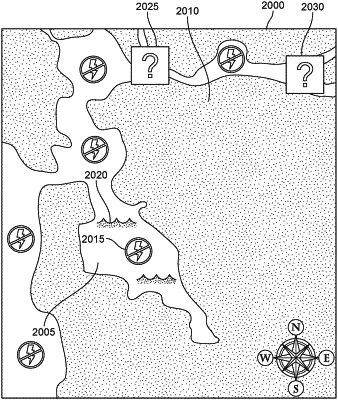
prepare a map including at least one icon associated with a type of disaster condition as determined and at least one icon identifying the at least one unphotographed location where the at least one image is needed;
provide the map to the personal devices of the registered users;
receive a selection of a selected unphotographed location from the map where at least one image is to be acquired by one of the registered users;
wherein the selection of the selected unphotographed location is based on the registration information and a selection by the registered user of an icon on the map corresponding to the selected unphotographed location;
instruct a drone owned by the registered user to acquire an aerial image of the selected unphotographed location;
receive the aerial image of the selected unphotographed location from the drone using a physical connection, based on the registration information;
determine a determined disaster condition at the selected unphotographed location based on the aerial image of the selected unphotographed location;
use a land vehicle drone to obtain air quality data and an additional ground-based image of the selected unphotographed location autonomously in an area where an effectiveness of the aerial image is limited;
use the additional image to further determine the determined disaster condition at the selected unphotographed location;
update the map by changing an icon on the map to correspond to the determined disaster condition to produce an updated map; and
provide the updated map to the personal devices of the registered users;
wherein the updated map includes information related to performing at least one disaster response strategy responsive to the disaster conditions in the geographic region;
wherein the at least one disaster response strategy is prioritized based on corresponding types of the disaster conditions.
|