| CPC G06Q 30/0633 (2013.01) [B64C 39/024 (2013.01); G01C 21/206 (2013.01); G01C 21/343 (2013.01); G01C 21/3446 (2013.01); G01S 7/4808 (2013.01); G01S 17/06 (2013.01); G01S 17/894 (2020.01); G06T 7/75 (2017.01); G06T 17/05 (2013.01); B64U 2101/30 (2023.01); G06Q 30/0601 (2013.01)] | 20 Claims |

|
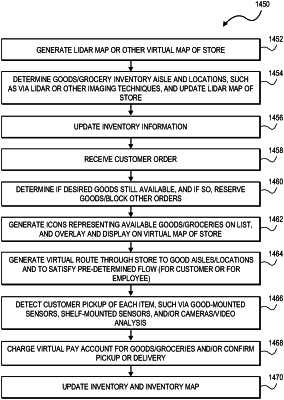
1. A computer-implemented method for commercial inventory mapping, the method comprising, via one or more local or remote processors, sensors, servers, light detection and ranging (LIDAR) devices, and/or transceivers:
receiving LIDAR data generated from a LIDAR camera, the LIDAR data associated with a store or a store layout;
generating a LIDAR-based virtual map of the store from processor analysis of the LIDAR data;
receiving, with a server, sensor data from a sensor;
updating an electronic inventory list based upon the received sensor data;
determining locations of individual goods on the updated inventory list in the store;
overlaying the locations of the individual goods onto the LIDAR-based virtual map; and
generating an updated LIDAR-based virtual map of the store displaying aisles of the store and the overlaid locations of the individual goods within the store.
|