| CPC G01C 21/3811 (2020.08) [G01C 21/3848 (2020.08); G06T 17/05 (2013.01)] | 19 Claims |

|
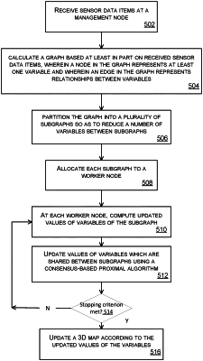
1. A method for updating a three dimensional (3D) map of an environment, the 3D map comprising sensor data items depicting the environment, the method comprising:
receiving, at a management node of a communications network comprising a plurality of worker nodes, the sensor data items, each of the sensor data items having an associated variable, a variable being a pose of a capture device or a position of a landmark, the sensor data items having been captured by the capture devices, wherein the landmark is located within the environment;
using at least the received sensor data items, calculating a graph, wherein the graph comprises nodes and edges, wherein a node represents a variable and wherein an edge represents a relationships between variables;
partitioning the graph into a plurality of subgraphs;
allocating each of the plurality of subgraphs to a respective one of the worker nodes of the plurality of worker nodes;
at each worker node, computing updated values of the variables of the subgraph;
updating values of variables which are shared between subgraphs to a common value using a consensus process, the updating including performing a global optimization on the variables to constrain the values of the variables shared between the plurality of the subgraphs to be the same; and
updating the 3D map according to the updated values of the variables.
|