| CPC G01B 11/002 (2013.01) [G01C 15/002 (2013.01); G01C 15/06 (2013.01)] | 17 Claims |

|
1. A method for surveying and/or marking points on an object on the basis of planned positions for purposes of constructional activities, with the steps of
setting up a stationary surveying device at a first known positioning in a surrounding area of the object, wherein the surveying device has
a base,
a targeting unit, in particular a telescopic sight, which defines a target direction (x) and can be pivoted with respect to the base about at least one axis (y, z), in particular two axes orthogonal to one another,
a beam source, in particular a laser source, for generating radiation and also an optical unit for emitting the radiation as a free beam in the target direction, wherein the free beam serves for surveying and/or marking object points,
at least one angle meter and also an angle-measuring functionality for measuring the target direction (x), and
a controller with single-point determining functionality,
a memory, in which input or surveyed positions can be stored, in particular as part of a plan of a building or room,
retrieving from the memory a set of object points of the object to be surveyed and/or to be marked,
surveying and/or marking from the first positioning (P1) object points of the set of object points that can be surveyed and/or can be marked from the first positioning (P1) by means of the free beam, on the basis of the target direction (x),
ascertaining missing object points of the set of object points,
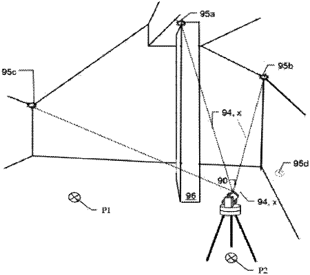
relocating the surveying device to a second, unknown positioning (P2) in the surrounding area of the object,
automatically determining the second positioning (P2) by the surveying device on the basis of the knowledge of the first positioning (P1), so that the second positioning (P2) is known,
surveying and/or marking missing object points by means of the free beam from the second positioning (P2).
|