| CPC E21B 47/085 (2020.05) [E21B 47/0025 (2020.05); E21B 47/09 (2013.01); G01S 17/89 (2013.01)] | 20 Claims |

|
1. A system, comprising:
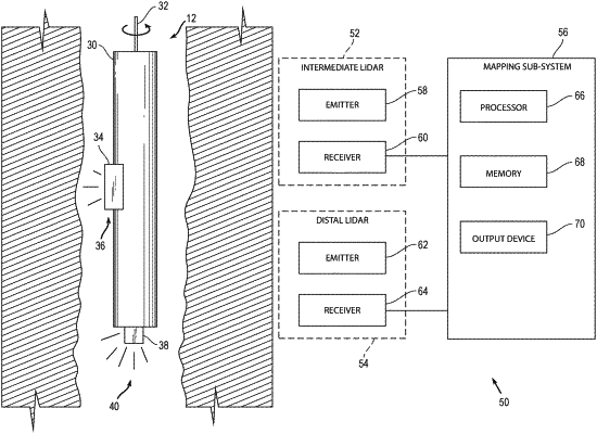
a tool having a longitudinal length extending along a longitudinal axis of the tool, with the tool configured to be positioned in a borehole, the tool including:
a distal LIDAR sub-system disposed at a distal position of the tool, with the distal LIDAR sub-system having a distal emitter and a distal receiver, wherein the distal emitter emits a first light in a first direction along the longitudinal axis which is towards a distal object in the borehole, and wherein the distal receiver receives reflected light from the distal object to determine a characteristic of the distal object;
an intermediate LIDAR sub-system disposed at an intermediate position along the longitudinal length, with the intermediate LIDAR sub-system having an intermediate emitter and an intermediate receiver, wherein the intermediate emitter emits a second light in a second direction perpendicular to the longitudinal axis and which is towards an intermediate object in the borehole, wherein the intermediate emitter emits the second light in the second direction after the distal emitter emits the first light in the first direction, and wherein the intermediate receiver receives reflected light from the intermediate object to determine a characteristic of the intermediate object; and
a mapping sub-system including a hardware processor having code therein configured to determine a position of the tool in the borehole from the characteristic of the distal object, and then to determine an inner surface of the borehole from the characteristic of the intermediate object after determining the position of the tool from the characteristic of the distal object using the distal receiver, and then to generate and output a map of the borehole from the position of the tool and from the inner surface.
|