| CPC G08B 7/066 (2013.01) [B64C 39/024 (2013.01); G05D 1/106 (2019.05); G08B 17/125 (2013.01); H04W 4/024 (2018.02); H04W 4/025 (2013.01); H04W 4/90 (2018.02); B64U 2101/00 (2023.01); B64U 2101/30 (2023.01); B64U 2201/10 (2023.01)] | 20 Claims |

|
1. A computer system for providing wildfire evacuation support, said computer system comprising:
an input for receiving sensor data generated by at least one unmanned aerial vehicle while deployed within a target region that contains a wildfire, the at least one unmanned aerial vehicle being configured to generate, by use of one or more sensors, said sensor data that represents the wildfire with in the target region;
at least one processor connected to said input and configured to:
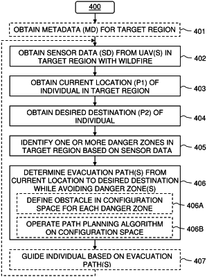
obtain a current location of an individual in a hazardous situation in the target region;
obtain a desired destination for the individual in the target region;
identify, based on the sensor data, one or more danger zones in the target region, the one or more danger zones posing a fire-related threat to the individual; and
determine at least one evacuation path that extends from the current location to the desired destination while avoiding the one or more danger zones,
wherein the computer system is configured to:
represent in a configuration space of a path planning algorithm each of the one or more danger zones as an obstacle defined having a margin that represents a safe distance between the individual and the respective danger zone;
set each of the margins of the obstacles based on at least one of wind data and/or a characteristic of the wildfire; and
operate the path planning algorithm to determine the at least one evacuation path.
|