| CPC G08B 17/005 (2013.01) [G06F 16/29 (2019.01); G06T 7/77 (2017.01); G06T 11/20 (2013.01); G06T 2207/10032 (2013.01); G06T 2210/12 (2013.01)] | 20 Claims |

|
1. A computer-implemented method comprising:
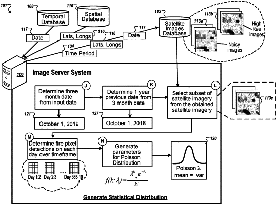
obtaining, by a server, a satellite image of a geographic region and a date corresponding to when the satellite image was generated;
determining, by the server, a number of pixels in the obtained satellite image that are indicated as on fire;
obtaining, by the server, satellite imagery of the geographic region over a time period from before the date when the satellite image was generated;
generating, by the server, a statistical distribution over the time period from the obtained satellite imagery that reflects a number of pixels that each image of the obtained satellite imagery illustrates fire;
determining, by the server, a likelihood that the obtained satellite image illustrates fire based on a comparison of the determined number of pixels in the satellite image that are indicated as on fire to the generated statistical distribution;
comparing, by the server, the determined likelihood to a threshold;
determining, by the server, that the determined likelihood satisfies the threshold; and
in response to determining that the determined likelihood satisfies the threshold, providing, by the server, an indication that the obtained satellite image illustrates fire.
|