US 12,079,445 B2
Map-based graphical user interface indicating geospatial activity metrics
Daniel Amitay, New York, NY (US); Jonathan Brody, Marina Del Rey, CA (US); Maxwell Gale, New York, NY (US); Timothy Jordan Garcia, Toronto (CA); Daniel Vincent Grippi, New York, NY (US); Jeffrey Arthur Johnson, Brooklyn, NY (US); Sheridan Kates, New York, NY (US); Andrew Lin, Long Island City, NY (US); Walton Lin, Chatham, NJ (US); Gaurav Misra, New York, NY (US); Suraj Vindana Samaranayake, New York, NY (US); Amer Shahnawaz, Venice, CA (US); and Evan Spiegel, Los Angeles, CA (US)
Assigned to Snap Inc., Santa Monica, CA (US)
Filed by Snap Inc., Santa Monica, CA (US)
Filed on May 12, 2023, as Appl. No. 18/196,915.
Application 18/196,915 is a continuation of application No. 17/879,607, filed on Aug. 2, 2022, granted, now 11,782,574.
Application 17/879,607 is a continuation of application No. 15/965,811, filed on Apr. 27, 2018, granted, now 11,409,407.
Claims priority of provisional application 62/556,134, filed on Sep. 8, 2017.
Claims priority of provisional application 62/552,958, filed on Aug. 31, 2017.
Claims priority of provisional application 62/491,115, filed on Apr. 27, 2017.
Prior Publication US 2023/0280879 A1, Sep. 7, 2023
This patent is subject to a terminal disclaimer.
Int. Cl. G06F 3/04817 (2022.01); G06F 3/0482 (2013.01); G06F 3/04842 (2022.01); G06F 3/0488 (2022.01); G06F 16/248 (2019.01); G06F 16/29 (2019.01); G06F 16/487 (2019.01); G06F 16/9535 (2019.01); G06F 16/9537 (2019.01); G06Q 50/00 (2024.01); G06T 11/20 (2006.01); G06T 11/60 (2006.01); H04L 9/40 (2022.01); H04L 41/22 (2022.01); H04L 41/28 (2022.01); H04L 51/52 (2022.01); H04L 67/12 (2022.01); H04L 67/306 (2022.01); H04L 67/50 (2022.01); H04L 67/52 (2022.01); H04W 4/02 (2018.01); H04W 4/029 (2018.01); H04W 4/18 (2009.01); H04W 4/21 (2018.01); H04W 12/02 (2009.01); G06F 9/54 (2006.01)
CPC G06F 3/04817 (2013.01) [G06F 3/0482 (2013.01); G06F 3/04842 (2013.01); G06F 3/0488 (2013.01); G06F 16/248 (2019.01); G06F 16/29 (2019.01); G06F 16/487 (2019.01); G06F 16/9535 (2019.01); G06F 16/9537 (2019.01); G06Q 50/01 (2013.01); G06T 11/206 (2013.01); G06T 11/60 (2013.01); H04L 41/22 (2013.01); H04L 41/28 (2013.01); H04L 51/52 (2022.05); H04L 63/101 (2013.01); H04L 63/107 (2013.01); H04L 67/12 (2013.01); H04L 67/306 (2013.01); H04L 67/52 (2022.05); H04L 67/535 (2022.05); H04W 4/02 (2013.01); H04W 4/029 (2018.02); H04W 4/185 (2013.01); H04W 4/21 (2018.02); H04W 12/02 (2013.01); G06F 9/547 (2013.01); G06T 2200/24 (2013.01)] 16 Claims
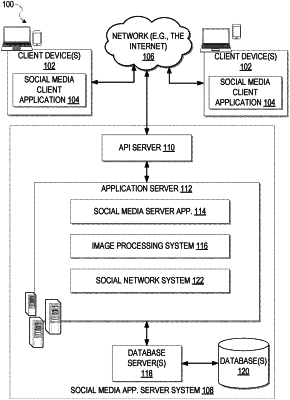
OG exemplary drawing
 
1. A method comprising:
causing display of a map-based graphical user interface (GUI) for a social media platform on a user device associated with a particular user, the map-based GUI including enabling user navigation to display a target geographical area; and
responsive to user input, selectively switching the map-based GUI between:
a live mode in which the map-based GUI provides location-based access to social media content comprising ephemeral items uploaded by users to the social media platform for public availability, each ephemeral item originating from the target geographical area and having a respective predefined limited period of time between uploading and expiry of the respective ephemeral item, expired ephemeral items being inaccessible for viewing in the live mode of the map-based GUI; and
a historical mode in which the map-based GUI provides location-based access exclusively to geotagged historical social media content previously uploaded by the particular user, the geotagged historical media content including expired ephemeral items uploaded by the particular user.