| CPC H04W 4/029 (2018.02) [G06F 16/2228 (2019.01); G06F 16/29 (2019.01); G06F 16/93 (2019.01); G06Q 30/0205 (2013.01); G06Q 30/0261 (2013.01); H04L 67/53 (2022.05); H04W 4/021 (2013.01)] | 20 Claims |

|
1. A geo-fencing method, comprising:
at one or more first computer systems coupled to a packet-based network and including or having access to electronic storage media storing therein events associated with mobile devices communicating with the packet-based network using signals, each respective event of the events identifying a mobile device, a time of the respective event, and a location of the mobile device at the time of the respective event;
receiving an application program interface (API) call from a second computer system via the packet-based network;
in response to the API call, enabling the second computer system to display a user interface (UI) on a display screen of the second computer system, the UI including one or more screen areas configured to display input parameters received by the second computer system for defining and/or tuning a geo-fence, the input parameters including some or all of: at least one keyword, at least one location, one or more tuning parameters, and one or more demographic definitions, wherein the UI is further configurable to display the geo-fence over a map;
receiving the input parameters from the second computer system via the packet-based network;
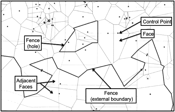
in response to receiving the input parameters, generating the geo-fence, including: sampling events stored in the electronic storage media using some or all of the input parameters, dividing a geographical region around the at least one location into a plurality of geographical areas based on sampled events, determining a weight for each of the plurality of geographical areas based at least on the input parameters and the sample events, selecting a subset of the plurality of geographical areas based on the weights of the plurality of geographical areas, and forming the geo-fence using the subset of the plurality of geographical areas, the geo-fence including one or more regions, each of the one or more regions including a cluster of geographical areas among the subset of the plurality of geographical areas, each area in the cluster of geographical areas being adjacent to at least one other area in the cluster of geographical areas; and
transmitting information associated with the geo-fence to the second computer system via the packet-based network, to cause the UI to display the geofence over a map on the display screen of the second computer system.
|