| CPC H04B 17/391 (2015.01) [G06F 30/18 (2020.01); G06T 15/005 (2013.01); G06T 15/04 (2013.01); G06T 15/08 (2013.01); G06T 17/10 (2013.01); H04B 17/318 (2015.01); H04B 17/336 (2015.01); H04W 16/20 (2013.01)] | 20 Claims |

|
1. A method for visualizing a Radio Frequency (RF) propagation pattern based on a building plan defined with implicit geometry, the method comprising:
extracting data from a building plan file, wherein a three-dimensional space and objects in the building plan are defined with the implicit geometry;
transforming the implicit geometry to explicit geometry for the three-dimensional space and the objects to translate a positioning of the three-dimensional space and the objects from a local coordinate system to a global coordinate system;
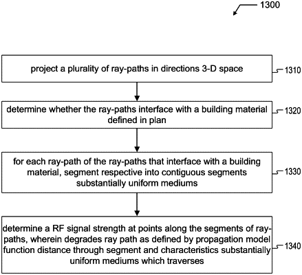
projecting a plurality of ray paths in a plurality of directions from each of a plurality of Wi-Fi access points;
identifying objects that intersect with one or more of the plurality of ray paths;
calculating a RF propagation pattern in the three-dimensional space based on a RF propagation model for a plurality of Wi-Fi access points located in the three-dimensional space, the plurality of ray paths, and the objects that intersect the one or more of the plurality of ray paths; and
presenting a three-dimensional visualization of the RF propagation pattern in the three-dimensional space.
|