| CPC G06T 7/55 (2017.01) [B64C 39/024 (2013.01); G06T 3/4038 (2013.01); H04N 23/698 (2023.01); B64U 2101/30 (2023.01); B64U 2201/104 (2023.01); G06T 2207/10028 (2013.01)] | 19 Claims |

|
1. A method performed by an apparatus of a drone, the method comprising:
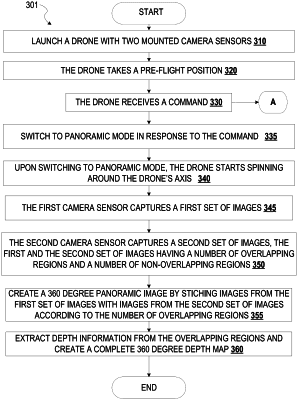
simultaneously capturing a plurality of first images by a first camera sensor a plurality of second images by a second camera sensor, and capturing depth information by a third camera sensor while the drone spins around an axis of the drone, wherein the first camera sensor and the second camera sensor each have a field of view of more than 180 degrees, wherein the plurality of first images has a plurality of overlapping regions with the plurality of second images, wherein the first camera sensor is mounted on the drone a predetermined distance from the second camera sensor, and wherein the third camera sensor is mounted on the drone;
processing, by one or more processors, the plurality of first images and the plurality of second images to create a 360-degree image by stitching the plurality of first images together with the plurality of second images according to a corresponding overlapping region of the plurality of overlapping regions; and
processing, by one or more processors, the plurality of overlapping regions and the captured depth information to generate a 360-degree depth map for the 360-degree image, wherein the plurality of overlapping regions cover a 360-degree range of the 360-degree image.
|