| CPC G06T 7/521 (2017.01) [G06T 7/20 (2013.01); G06T 2207/10028 (2013.01); G06T 2207/20084 (2013.01)] | 17 Claims |

|
1. A method comprising:
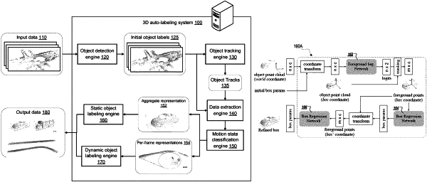
obtaining a sensor data segment comprising a temporal sequence of three-dimensional point clouds generated from sensor readings of an environment by one or more sensors, each three-dimensional point cloud comprising a respective plurality of points in a first coordinate system;
identifying, from the sensor data segment, (i) a plurality of object tracks that each corresponds to a different object in the environment and (ii) for each object track, respective initial three-dimensional regions in each of one or more of the point clouds in which the corresponding object appears, wherein each initial three-dimensional region is an initial estimate of the three-dimensional region of the point cloud that includes points that are measurements of the corresponding object, wherein the identifying comprises:
processing each of the point clouds in the temporal sequence using an object detector to obtain, for each point cloud, a detector output that identifies a plurality of three-dimensional regions in the point cloud that are predicted to correspond to objects; and
processing the detector output using an object tracker to obtain an object tracker output that associates each of at least a subset of the three-dimensional regions in each of the point clouds with a respective one of the plurality of object tracks;
generating, for each object track, extracted object track data that includes at least the points in the respective initial three-dimensional regions for the object track; and
generating, for each object track and from the extracted object track data for the object track, an auto labeling output that defines respective refined three-dimensional regions in each of the one or more point clouds that is a refined estimate of the three-dimensional region of the point cloud that includes points that are measurements of the corresponding object.
|