US 12,073,471 B1
Systems and methods for unmanned vehicle management
Anthony Scott Farnsworth, San Antonio, TX (US); Justin Dax Haslam, San Antonio, TX (US); Kathleen L. Swain, Kemah, TX (US); Teddy Joseph Edmond Voutour, Helotes, TX (US); Jess W. Gingrich, San Antonio, TX (US); Michael J. Allen, San Antonio, TX (US); Anthony G. Castiglione, San Antonio, TX (US); and Jordan A. Newmark, Fair Oaks Ranch, TX (US)
Assigned to United Services Automobile Association (USAA), San Antonio, TX (US)
Filed by United Services Automobile Association (USAA), San Antonio, TX (US)
Filed on May 10, 2023, as Appl. No. 18/315,324.
Application 18/315,324 is a continuation of application No. 17/075,600, filed on Oct. 20, 2020, granted, now 11,688,014.
Application 17/075,600 is a continuation of application No. 16/123,329, filed on Sep. 6, 2018, granted, now 10,810,679, issued on Oct. 20, 2020.
Application 16/123,329 is a continuation of application No. 14/873,810, filed on Oct. 2, 2015, granted, now 10,102,590, issued on Oct. 16, 2018.
Claims priority of provisional application 62/058,990, filed on Oct. 2, 2014.
Claims priority of provisional application 62/108,137, filed on Jan. 27, 2015.
Claims priority of provisional application 62/140,107, filed on Mar. 30, 2015.
Claims priority of provisional application 62/148,823, filed on Apr. 17, 2015.
Int. Cl. G06Q 40/08 (2012.01); G08G 5/00 (2006.01); G09C 5/00 (2006.01); H04L 9/08 (2006.01); H04L 9/32 (2006.01); G06Q 10/0633 (2023.01)
CPC G06Q 40/08 (2013.01) [G08G 5/0034 (2013.01); G08G 5/0069 (2013.01); G09C 5/00 (2013.01); H04L 9/08 (2013.01); H04L 9/0825 (2013.01); H04L 9/3226 (2013.01); G06Q 10/0633 (2013.01); H04L 2209/84 (2013.01)] 20 Claims
OG exemplary drawing
 
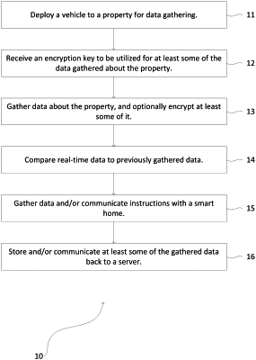
1. A method comprising:
deploying a vehicle to a property to gather data related to a loss;
determining a path for the vehicle to gather data related to the loss;
causing the vehicle to gather real-time data associated with a property while traveling the path;
comparing the real-time data to previously-gathered data associated with the property; and
determining a portion of the property that is damaged in the real-time data based on the comparison of the real-time data to the previously-gathered data.