| CPC G06T 7/251 (2017.01) [G06T 7/75 (2017.01); G06T 17/205 (2013.01); G06T 19/20 (2013.01); G06T 2207/10016 (2013.01); G06T 2207/30241 (2013.01); G06T 2207/30244 (2013.01); G06T 2219/2004 (2013.01)] | 31 Claims |
|
29. A system comprising:
one or more hardware processors of one or more computing devices; and
one or more memories with stored instructions that, when executed by at least one of the one or more hardware processors, cause the one or more computing devices to perform automated operations including at least:
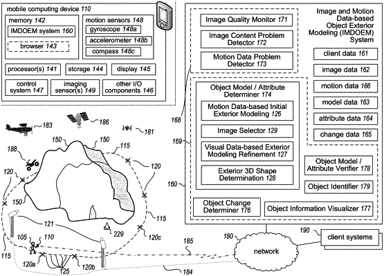
obtaining information about a plurality of images captured during an image acquisition session at multiple positions around an exterior of a pile of material that is deposited at a fixed site and about metadata from capturing of the plurality of images, wherein the metadata is based at least in part on data from one or more motion sensors of at least one device involved in the capturing of the succession of images and includes a plurality of estimated pose data points with an estimated pose data point for each image of the succession indicating location and orientation of the at least one device during the capturing of that image;
generating, based on a combination of the metadata and of visual data from at least some images of the plurality, a completed three-dimensional (“3D”) computer model representing the exterior of the pile of material, including:
determining, using estimated pose data points for images of the plurality, initial trajectory information that indicates at least one sequence of estimated pose data points of the at least one device during the capturing of at least some images of the plurality;
determining, based at least in part on analysis of visual data from images of the plurality, an image sequence having multiple images that are a subset of the plurality of images and such that each image in the image sequence has, for one or more adjacent images in the image sequence, an amount of visual overlap with the one or more adjacent images that satisfies one or more defined visual overlap criteria;
determining updated trajectory information for the multiple images of the image sequence that includes pose data points with revised location and orientation values, including modifying the estimated pose data points of the initial trajectory information based on triangulations across images of the image sequence of positions of features that are each visible in at least two images of the image sequence;
determining, based at least in part on the updated trajectory information, positions of a plurality of 3D points on the exterior of the pile of material, including, for each of multiple 3D points that are visible in two or more images of the image sequence, aligning that 3D point's position across the two or more images; and
using the determined positions of the plurality of 3D points to generate the completed 3D computer model representing the exterior of the pile of material; and
transmitting, to one or more client devices, at least some of the completed generated 3D computer model, to enable each of the one or more client devices to display the at least some completed generated 3D computer model overlaid on a current image of an environment of that client device, wherein the displayed at least some completed generated 3D computer model includes at least one of a 3D surface corresponding to the at least some of the completed generated 3D computer model or some or all of the plurality of 3D points.
|