| CPC G06Q 50/16 (2013.01) [G06F 3/04845 (2013.01); G06F 16/29 (2019.01); G06Q 30/0613 (2013.01); G06F 3/0482 (2013.01); G06F 2203/04806 (2013.01); G09G 5/377 (2013.01); G09G 2370/022 (2013.01)] | 19 Claims |
|
1. A server device to:
receive, from a user device, a request to display a map image via a graphical user interface (GUI) of the user device, the request comprising an indication of a zoom level, the map image being divided into a plurality of map quadkeys;
access a data store to retrieve a plurality of property data items corresponding to the map image, each of the plurality of property data items corresponding to a real estate property of a plurality of real estate properties;
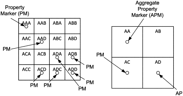
generate and assign, for each of the plurality of property data items, a property quadkey to obtain a plurality of property quadkeys;
filter, using a first map quadkey of the plurality of map quadkeys, the plurality of property data items to obtain two or more property data items of the plurality of property data items, the two or more property data items corresponding to two or more real estate properties of the plurality of real estate properties;
aggregate the two or more property data items into an aggregate property marker, the aggregate property marker identifying a location of the two or more real estate properties;
generate an aggregate quadkey for the aggregate property marker, wherein the aggregate quadkey is a truncated portion of corresponding property quadkeys of the two or more property data items; and
transmit, to the user device, a response to cause the user device to display, via the GUI, the aggregate property marker overlaid on the map image based on the aggregate quadkey and the first map quadkey;
wherein the request further comprises a second indication of a geographic region and a plurality of tasks, each of the plurality of tasks comprising a corresponding deadline and a corresponding address;
wherein the server device is to filter the plurality of tasks to obtain two or more of the plurality of tasks that have corresponding addresses within the geographic region and that have corresponding deadlines within a threshold amount of time;
wherein the server is to generate one or more property markers for the two or more of the plurality of tasks, the one or more property markers comprising the aggregate property marker; and
wherein the response is to cause the user device to display, via the GUI, the one or more property markers overlaid on the map image based on corresponding property quadkeys and corresponding map quadkeys.
|