| CPC G06F 16/906 (2019.01) [G06F 16/687 (2019.01); G06F 16/75 (2019.01); G06F 16/22 (2019.01); G06F 16/2457 (2019.01)] | 20 Claims |
|
1. A method comprising:
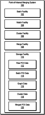
accessing, by a computing system communicatively coupled to systems operated by providers of point-of-interest data, a plurality of point-of-interest data records from the systems, each of the plurality of point-of-interest data records including data representative of a distinct set of features for a distinct point-of-interest associated with a distinct geographic location;
generating, by the computing system and based on the plurality of point-of-interest data records, a graph data structure that includes a plurality of nodes representing the plurality of point-of-interest data records and a plurality of edges representing a plurality of weighted feature relationships interconnecting the plurality of point-of-interest data records;
generating, by the computing system based on the graph data structure, one or more merged point-of-interest data records; and
storing, by the computing system, the one or more merged point-of-interest data records to a points-of-interest data store in a storage device for access and use by a computer-implemented mapping system to indicate one or more points-of-interest on a display of a user interface map of a geographic area.
|