| CPC G01V 1/38 (2013.01) [G01V 1/282 (2013.01); G01V 1/286 (2013.01); G01V 1/305 (2013.01); G01V 2210/512 (2013.01); G01V 2210/514 (2013.01); G01V 2210/675 (2013.01)] | 17 Claims |
|
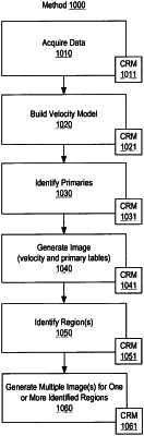
1. A method comprising:
receiving seismic data for a geologic region of the Earth, wherein the seismic data comprise primaries and multiples acquired using a seismic survey geometry that comprises a two-dimensional array;
building a velocity model that physically characterizes the geologic region of the Earth, wherein the velocity model comprises at least three reflecting interfaces at different subsurface depths in a range from shallow to deep;
generating a primary image using the seismic data;
identifying a portion of the geologic region of the Earth in the primary image that comprises a deficiency in coverage at shallower subsurface depths that comprise structural geological variations, wherein the deficiency in coverage corresponds to one or more gaps in the two-dimensional array of the seismic survey geometry;
selecting at least one mode of multiple from the multiples and corresponding travel time data from a data storage wherein the travel time data correspond to at least one complex ray signature in the geologic region of the Earth and are based at least in part on the velocity model, and wherein the travel time data comprise entries for source to image point travel time data and entries for image point to receiver travel time data;
based on the selected at least one mode of multiple, pre-processing the seismic data to generate attenuated seismic data;
performing Kirchhoff migration on the attenuated seismic data using at least the selected travel time data to generate migrated seismic data, wherein the selected travel time data comprise one or more of the entries for source to image point travel time data and one or more of the entries for image point to receiver travel time data; and
rendering an image of the geologic region of the Earth to a display to determine a location of hydrocarbons wherein the image comprises at least a multiple image based at least in part on the migrated seismic data that improves the coverage at the shallower subsurface depths to highlight the structural geological variations.
|